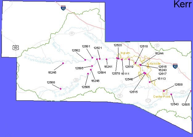
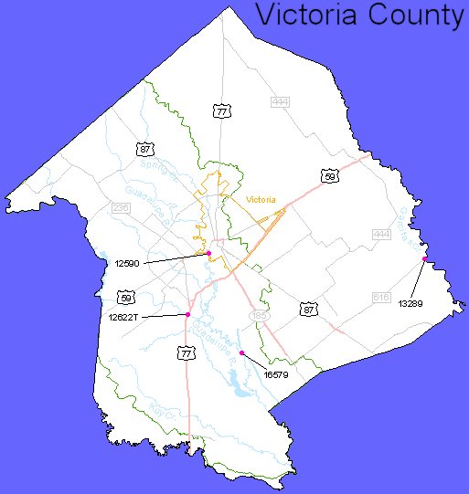
Clean Rivers Program

The Texas Clean Rivers Program (CRP) is a statewide program established to holistically manage water quality issues throughout the state. GBRA partners with the Texas Commission on Environmental Quality (TCEQ) to administer the CRP for the Guadalupe River and Lavaca-Guadalupe Coastal Basins. The CRP is managed by the TCEQ and is funded entirely by fees assessed to wastewater discharge and water rights permit holders. The program’s objectives are to provide quality assured data to the TCEQ for use in decision making, identify and evaluate water quality issues, promote cooperative watershed planning, recommend management strategies, inform and engage stakeholders, and maintain efficient use of public funds. GBRA, along with the Upper Guadalupe River Authority (UGRA), carry out the water quality management efforts in these basins under contract with the TCEQ. The Wimberley Valley Watershed Association (WVWA) contributes monitoring data collected under the Guadalupe Basin CRP quality assurance project plan from the Blanco River and Cypress Creek watersheds.

Prepared in cooperation with the Texas Commission on Environmental Quality.

Monitoring Sites Map

To get more information about monitoring sites in a given county, click a marker on the map.

Water Quality Data

BLANCO COUNTY MONITORING SITES

On the bottom, there is a table of sites with locations, parameters and frequency of analysis. Below the table is a legend defining the abbreviations used in the table.

Guadalupe River Basin Surface Water Quality Monitoring Program
Wimberley Valley Watershed/Meadows Center for Water and the Environment
Monitoring Locations


TCEQ Station ID Description Latitude / Longitude Parameters / Frequency* Monitoring Types/By Data to August 2012 Data from September 2020
12668 Blanco River at FM 165 bridge crossing near City of Blanco 30°05’27” / -98°24’06” C/Monthly; F/Monthly; BAC/Monthly Fixed/WVWA Excel Excel
12669 Blanco River at Blanco State Park PR 23 30°05’28.4″ / -98°25’27” C/Monthly; F/Monthly; BAC/Monthly Fixed/WVWA Excel
17528 Blanco River immediately upstream of River Run and Pany Dr 30°05’50” / -98°26’07” C/Monthly; F/Monthly; BAC/Monthly Fixed/WVWA Excel

Legend

The C symbol represents the following parameters and their TCEQ codes: 00010, Temperature, Water (Centigrade); 00094 Conductivity, Field (mmhos/cm @ 25C); 00300 Oxygen, Dissolved (mg/L); 00400 pH (standard units); 00631 Nitrate/Nitrite-Nitrogen (mg/L as N); 00665 Total Phosphorus (mg/L as P); 00530 Solids, Total Suspended (mg/L); 82079 Turbidity (NTU); 00945 Sulfate (mg/L); 00940 Chloride (mg/L); 32211 Chlorophyll-a (mg/L); 00900 Total Hardness (mg/L); and 31648 E. coli (#/100 mL).

The F symbol means that a flow measurement will be provided. When possible, this information will be derived from U.S. Geological stream gages; at some sites, the proximity of a hydroelectric generating facility allows the calculation of flow based upon power generated; at the remainder of the sites field measurements will be made by GBRA Lab personnel or UGRA personnel.

The M symbol denotes metals. All M samples will be collected by the GBRA. The dissolved metals to be analyzed for are 01106 Aluminum (mg/L as Al); 01090 Zinc (mg/L as Zn); 01000 Arsenic (mg/L as As); 00915 Calcium (mg/L as Ca); 01025 Cadmium (mg/L as Cd); 00925 Magnesium (mg/L as Mg); 46570 Hardness, calc, (mg/L as CaCO3); 01005 Barium (mg/L as Ba); 01030 Chromium (mg/L as Cr); 01040 Copper (mg/L as Cu); 01046 Iron (mg/L as Fe); 01049 Lead (mg/L as Pb); 01056 Manganese (mg/L as Mn); 01065 Nickel (mg/L as Ni); 01060 Molybdenum (mg/L as Mo); 01145 Selenium (mg/L as Se); 71890 Mercury, total (mg/L as Hg); and 01075 Silver (mg/L as Ag).

AC means Aquatic Commun-Habitat.

RN means Routine Nekton.

N/A means not active. The station is not being monitored.

RB means Routine Benthics.

FT means Fish Tissue.

BAC means TSWQS Bacteria sampling.

O means organics in water.

D024 means dissolved oxygen measurements over a 24 hour period.

Caldwell County Monitoring Sites

On the bottom, there is a table of sites with locations, parameters and frequency of analysis. Below the table is a legend defining the abbreviations used in the table.

Guadalupe River Basin Surface Water Quality Monitoring Program
GBRA Monitoring Locations
TCEQ Station ID Description Latitude / Longitude Parameters / Frequency* Monitoring Types/By Data to August 2020 Data from September 2020
12626 San Marcos River at Luling Water Treatment Plant 29°40’02” / -97°39’14” C/Monthly; F/Monthly; M/Annually; BAC/Monthly; O/Annual Fixed/GBRA Excel Excel
12640 Plum Creek at CR 135 SE of Luling 29°39’25” / -97°36’00” C/Monthly; F/Monthly; BAC/Monthly; O/Annual Fixed/GBRA Excel Excel
12645 Plum Creek at CR 197 Between Lockhart and Luling 29°49’16” / -97°35’02” Weather Targeted Monitoring GBRA Excel Excel
12647 Plum Creek at CR 202, SE of Lockhart 29°51’55” / -97°36’55” C/Monthly; F/Monthly; BAC/Monthly GBRA Excel Excel
Guadalupe River Basin Surface Water Quality Monitoring Program
TCEQ Monitoring Locations
TCEQ Station ID Description Latitude / Longitude Parameters / Frequency* Monitoring Types/By Historical Data
12647 Plum Creek at CR 202, SE of Lockhart 28°28’36” / -96°51’48” C/Quarterly; BAC/Quarterly; F/Quarterly Fixed/TCEQ** TCEQ

** The ability to look up data for a specific Station ID on the TCEQ website is no longer available. However, by using the TCEQ link above, it is possible to download text files for a segment; so if you know the segment, you can scroll down to it and select it for downloading. The data download query requires a great deal of knowledge of not only converting and combining text files, but also for understanding and looking up the codes in the Data Management Reference Guide.

Calhoun County Monitoring Sites

On the bottom, there is a table of sites with locations, parameters and frequency of analysis. Below the table is a legend defining the abbreviations used in the table.

Guadalupe River Basin Surface Water Quality Monitoring Program
GBRA Monitoring Locations
TCEQ Station ID Description Latitude / Longitude Parameters / Frequency* Monitoring Types/By Data to August 2020 Data from September 2020
12578 Guadalupe River upstream of Lower Guadalupe Diversion Dam and Salt Water Barrier 28°30’24” / -96°53’09” C/Monthly; M/Annually; F/Monthly; BAC/Monthly Fixed/GBRA Excel Excel
Guadalupe River Basin Surface Water Quality Monitoring Program
TCEQ Monitoring Locations
TCEQ Station ID Description Latitude / Longitude Parameters / Frequency* Monitoring Types/By Historical Data
12536 Victoria Barge Canal at SH 35 28°31’12” / 96°48’00” No monitoring scheduled for 2006 TCEQ
12577 Guadalupe River tidal bridge at SH 35 NE of Tivoli 28°28’36” / 96°51’48” C/Quarterly; BAC/Quarterly; DO24/Quarterly Fixed/TCEQ** TCEQ
13383 Lavaca Bay at SH 35 Causeway 28°38’20” / 96°36’32” C/Quarterly; BAC/Quarterly; DO24/Ann Fixed/TCEQ** TCEQ
13384 Lavaca Bay ‘Y’ intersection of Port Lavaca and MatagordaShip Channels at Marker 66 28°35’46” / 96°33’43” C/Quarterly; BAC/Quarterly; DO24/Ann Fixed/TCEQ** TCEQ
13385 Lavaca Bay at Alcoa Ship Channel off loading dock 28°39’36” / 96°34’48” C/Quarterly; BAC/Quarterly; DO24/Quarterly; M/Semi-ann; M-sed/Semi-ann; O-sed/Semi-ann Fixed/TCEQ** TCEQ
13386 Cox Bay SE of Point Comfort 28°37’48” / 96°32’24” C/Quarterly; BAC/Quarterly; O-sed/Semi-ann; M-sed/Semi-ann; M/Semi-ann Fixed/TCEQ** TCEQ
13396 Espiritu Santo Bay Intersection of Ferry and Intercostal 28°34’36” / 96°28’48” C/Quarterly; BAC/Quarterly TCEQ** TCEQ
13397 San Antonio Bay at CM 17 28°16’48” / 96°43’12” C/Quarterly; BAC/Quarterly Fixed/TCEQ** TCEQ
13563 Lavaca Bay 152 meters SSW of CM22 in Red Bluff Channel 28°40’48” / 96°34’48” C/Quarterly; BAC/Quarterly; M/Semi-ann; M-sed/Semi-ann; O-sed/Semi-ann; O/Semi-ann Fixed/TCEQ** TCEQ
14726 Powderhorn Lake 28°30’22” / 96°29’20” C/Quarterly; BAC/Quarterly Fixed/TCEQ** TCEQ
14951 Espiritu Santo Bay at ICWW at Fulgrums Fishing Camp 28°21’54” / 96°34’41” C/Quarterly; BAC/Quarterly Fixed/TCEQ** TCEQ

** The ability to look up data for a specific Station ID on the TCEQ website is no longer available. However, by using the TCEQ link above, it is possible to download text files for a segment; so if you know the segment, you can scroll down to it and select it for downloading. The data download query requires a great deal of knowledge of not only converting and combining text files, but also for understanding and looking up the codes in the Data Management Reference Guide.

Legend

The C symbol represents the following parameters and their TCEQ codes: 00010, Temperature, Water (Centigrade); 00094 Conductivity, Field (mmhos/cm @ 25C); 00300 Oxygen, Dissolved (mg/L); 00400 pH (standard units); 00631 Nitrate/Nitrite-Nitrogen (mg/L as N); 00665 Total Phosphorus (mg/L as P); 00530 Solids, Total Suspended (mg/L); 82079 Turbidity (NTU); 00945 Sulfate (mg/L); 00940 Chloride (mg/L); 32211 Chlorophyll-a (mg/L); 00900 Total Hardness (mg/L); and 31648 E. coli (#/100 mL).

The F symbol means that a flow measurement will be provided. When possible, this information will be derived from U.S. Geological stream gages; at some sites, the proximity of a hydroelectric generating facility allows the calculation of flow based upon power generated; at the remainder of the sites field measurements will be made by GBRA Lab personnel or UGRA personnel.

The M symbol denotes metals. All M samples will be collected by the GBRA. The dissolved metals to be analyzed for are 01106 Aluminum (mg/L as Al); 01090 Zinc (mg/L as Zn); 01000 Arsenic (mg/L as As); 00915 Calcium (mg/L as Ca); 01025 Cadmium (mg/L as Cd); 00925 Magnesium (mg/L as Mg); 46570 Hardness, calc, (mg/L as CaCO3); 01005 Barium (mg/L as Ba); 01030 Chromium (mg/L as Cr); 01040 Copper (mg/L as Cu); 01046 Iron (mg/L as Fe); 01049 Lead (mg/L as Pb); 01056 Manganese (mg/L as Mn); 01065 Nickel (mg/L as Ni); 01060 Molybdenum (mg/L as Mo); 01145 Selenium (mg/L as Se); 71890 Mercury, total (mg/L as Hg); and 01075 Silver (mg/L as Ag).

AC means Aquatic Commun-Habitat.

RN means Routine Nekton.

N/A means not active. The station is not being monitored.

RB means Routine Benthics.

FT means Fish Tissue.

BAC means TSWQS Bacteria sampling.

O means organics in water.

D024 means dissolved oxygen measurements over a 24 hour period.

Comal County Monitoring Sites

On the bottom, there is a table of sites with locations, parameters and frequency of analysis. Below the table is a legend defining the abbreviations used in the table.

Guadalupe River Basin Surface Water Quality Monitoring Program
GBRA Monitoring Locations
TCEQ Station ID Description Latitude / Longitude Parameters / Frequency* Monitoring Types/By Data to August 2020 Data from September 2020
12570 Dry Comal Creek at Seguin St., New Braunfels 29°42’16” / -98°07’45” C/Monthly; F/Monthly; M/Annually; AC/annual; RB/annual; RN/annual; BAC/Monthly Fixed/GBRA Excel Excel
12598 Canyon Reservoir (Canyon Park Marina) 29°53’57” / -98°13’24” C/Monthly; BAC/Monthly Fixed/GBRA Excel Excel
12653 Comal River at Hinman Island 29°42’29” / -98°07’26” C/Monthly; F/Monthly; BAC/monthly Fixed/GBRA Excel Excel
12656 Guadalupe River At Cypress Bend Park 29°42’50” / -98°06’25” C/Quarterly; F/Quarterly; BAC/Quarterly Fixed/GBRA Excel Excel
12658 Guadalupe River at River Road Second Crossing, upstream of New Braunfels 29°46’43” / -98°09’37” C/Monthly; F/Monthly; BAC/Monthly Fixed/GBRA Excel Excel
13700 Guadalupe River at RR 311, 1.9 mi SE of Spring Branch 29°53’00” / -98°23’00” C/Monthly; F/Monthly; BAC/Monthly Fixed/GBRA Excel Excel
15082 Comal River at Landa Park Area 16 29°42’35″ / -98°8’2″ C/Monthly; F/Monthly; BAC/Monthly Fixed/GBRA Excel Excel
15399 Honey Creek upstream of the Guadalupe River Quarterly GBRA Excel
16703 Guadalupe River at CR306 29°51’47” / -98°9’54” Retired Fixed/GBRA Excel
17443 Canyon Reservoir at Jacobs Creek Park 29°52’59” / -98°13’12” Retired Fixed/GBRA Excel
Guadalupe River Basin Surface Water Quality Monitoring Program
TCEQ Monitoring Locations
TCEQ Station ID Description Latitude / Longitude Parameters / Frequency* Monitoring Types/By Historical Data
12597 Canyon Lake at Canyon Dam 29°52’19” / 98°12’11” C/Quarterly; BAC/Quarterly Fixed/TCEQ** TCEQ
12600 Canyon Lake mid-lake south of Potters Creek Park at westend of park 29°53’45” / 98°16’57” C/Quarterly; BAC/Quarterly Fixed/TCEQ** TCEQ
12601 Canyon Lake headwaters above Cranes Mill Park 29°54’33” / 98°19’54” C/Quarterly; BAC/Quarterly; M-sed/Semi-ann Fixed/TCEQ** TCEQ
13511 Guadalupe River at Gruene Road crossing approx. 0.8 km SW of RR 306 in Gruene 29°44’17” / 98°06’22” C/Quarterly; F/Quarterly; BAC/Quarterly Fixed/TCEQ** TCEQ
16703 Guadalupe River 200 yds upstream of bridge on FM 306,0.5 mi downstream of Horseshoe Falls 29°51’47” / 98°09’50” C/Quarterly; BAC/Quarterly; F/Quarterly Fixed/TCEQ** TCEQ

** The ability to look up data for a specific Station ID on the TCEQ website is no longer available. However, by using the TCEQ link above, it is possible to download text files for a segment; so if you know the segment, you can scroll down to it and select it for downloading. The data download query requires a great deal of knowledge of not only converting and combining text files, but also for understanding and looking up the codes in the Data Management Reference Guide.

Legend

The C symbol represents the following parameters and their TCEQ codes: 00010, Temperature, Water (Centigrade); 00094 Conductivity, Field (mmhos/cm @ 25C); 00300 Oxygen, Dissolved (mg/L); 00400 pH (standard units); 00631 Nitrate/Nitrite-Nitrogen (mg/L as N); 00665 Total Phosphorus (mg/L as P); 00530 Solids, Total Suspended (mg/L); 82079 Turbidity (NTU); 00945 Sulfate (mg/L); 00940 Chloride (mg/L); 32211 Chlorophyll-a (mg/L); 00900 Total Hardness (mg/L); and 31648 E. coli (#/100 mL).

The F symbol means that a flow measurement will be provided. When possible, this information will be derived from U.S. Geological stream gages; at some sites, the proximity of a hydroelectric generating facility allows the calculation of flow based upon power generated; at the remainder of the sites field measurements will be made by GBRA Lab personnel or UGRA personnel.

The M symbol denotes metals. All M samples will be collected by the GBRA. The dissolved metals to be analyzed for are 01106 Aluminum (mg/L as Al); 01090 Zinc (mg/L as Zn); 01000 Arsenic (mg/L as As); 00915 Calcium (mg/L as Ca); 01025 Cadmium (mg/L as Cd); 00925 Magnesium (mg/L as Mg); 46570 Hardness, calc, (mg/L as CaCO3); 01005 Barium (mg/L as Ba); 01030 Chromium (mg/L as Cr); 01040 Copper (mg/L as Cu); 01046 Iron (mg/L as Fe); 01049 Lead (mg/L as Pb); 01056 Manganese (mg/L as Mn); 01065 Nickel (mg/L as Ni); 01060 Molybdenum (mg/L as Mo); 01145 Selenium (mg/L as Se); 71890 Mercury, total (mg/L as Hg); and 01075 Silver (mg/L as Ag).

AC means Aquatic Commun-Habitat.

RN means Routine Nekton.

N/A means not active. The station is not being monitored.

RB means Routine Benthics.

FT means Fish Tissue.

BAC means TSWQS Bacteria sampling.

O means organics in water.

D024 means dissolved oxygen measurements over a 24 hour period.

DeWitt County Monitoring Sites

On the bottom, there is a table of sites with locations, parameters and frequency of analysis. Below the table is a legend defining the abbreviations used in the table.

Guadalupe River Basin Surface Water Quality Monitoring Program
GBRA Monitoring Locations
TCEQ Station ID Description Latitude / Longitude Parameters / Frequency* Monitoring Types/By Data to August 2020 Data from September 2020
12592 Guadalupe River at FM 766 bridge near Cuero 29°08’49” / -97°19’02” C/Monthly; M/Annually; F/Monthly; BAC/Monthly Fixed/GBRA Excel Excel
13657 Sandies Creek at FM 240 29°13’12” / -97°27’07” C/Monthly; F/Monthly; BAC/Monthly Fixed/GBRA Excel Excel
14935 Sandies Creek CR 953 29°08’54” /- 97°21’53” Retired GBRA Excel

Legend

The C symbol represents the following parameters and their TCEQ codes: 00010, Temperature, Water (Centigrade); 00094 Conductivity, Field (mmhos/cm @ 25C); 00300 Oxygen, Dissolved (mg/L); 00400 pH (standard units); 00631 Nitrate/Nitrite-Nitrogen (mg/L as N); 00665 Total Phosphorus (mg/L as P); 00530 Solids, Total Suspended (mg/L); 82079 Turbidity (NTU); 00945 Sulfate (mg/L); 00940 Chloride (mg/L); 32211 Chlorophyll-a (mg/L); 00900 Total Hardness (mg/L); and 31648 E. coli (#/100 mL).

The F symbol means that a flow measurement will be provided. When possible, this information will be derived from U.S. Geological stream gages; at some sites, the proximity of a hydroelectric generating facility allows the calculation of flow based upon power generated; at the remainder of the sites field measurements will be made by GBRA Lab personnel or UGRA personnel.

The M symbol denotes metals. All M samples will be collected by the GBRA. The dissolved metals to be analyzed for are 01106 Aluminum (mg/L as Al); 01090 Zinc (mg/L as Zn); 01000 Arsenic (mg/L as As); 00915 Calcium (mg/L as Ca); 01025 Cadmium (mg/L as Cd); 00925 Magnesium (mg/L as Mg); 46570 Hardness, calc, (mg/L as CaCO3); 01005 Barium (mg/L as Ba); 01030 Chromium (mg/L as Cr); 01040 Copper (mg/L as Cu); 01046 Iron (mg/L as Fe); 01049 Lead (mg/L as Pb); 01056 Manganese (mg/L as Mn); 01065 Nickel (mg/L as Ni); 01060 Molybdenum (mg/L as Mo); 01145 Selenium (mg/L as Se); 71890 Mercury, total (mg/L as Hg); and 01075 Silver (mg/L as Ag).

AC means Aquatic Commun-Habitat.

RN means Routine Nekton.

N/A means not active. The station is not being monitored.

RB means Routine Benthics.

FT means Fish Tissue.

BAC means TSWQS Bacteria sampling.

O means organics in water.

D024 means dissolved oxygen measurements over a 24 hour period.

Goliad County Monitoring Sites

On the bottom, there is a table of sites with locations, parameters and frequency of analysis. Below the table is a legend defining the abbreviations used in the table.

Guadalupe River Basin Surface Water Quality Monitoring Program
GBRA Monitoring Locations
TCEQ Station ID Description Latitude / Longitude Parameters / Frequency* Monitoring Types/By Data to August 2020 Data from September 2020
12623 Coleto Creek Reservoir at Boat Launching Ramp 28°43’16” / -97°10’15” Retired Fixed/GBRA Excel
12790 San Antonio River FM 2506 east of Fannin 28°36’43” / -97°12’50” C/Monthly; F/Monthly; BAC/Monthly Fixed/GBRA Excel Excel
18594 Coleto Creek at Arnold Rd 28°51’40” / -97°13’34” Retired Fixed/GBRA PDF
18595 Perdido Creek at FM622 28°45’00” / -97°19’01” Retired Fixed/GBRA PDF
20827 Coleto Creek Reservoir at Dam 28°43’56” / -97°09’53” C/Monthly; F/Monthly; BAC/Monthly; Depth Profiles/Quarterly Fixed/GBRA PDF Excel

Legend

The C symbol represents the following parameters and their TCEQ codes: 00010, Temperature, Water (Centigrade); 00094 Conductivity, Field (mmhos/cm @ 25C); 00300 Oxygen, Dissolved (mg/L); 00400 pH (standard units); 00631 Nitrate/Nitrite-Nitrogen (mg/L as N); 00665 Total Phosphorus (mg/L as P); 00530 Solids, Total Suspended (mg/L); 82079 Turbidity (NTU); 00945 Sulfate (mg/L); 00940 Chloride (mg/L); 32211 Chlorophyll-a (mg/L); 00900 Total Hardness (mg/L); and 31648 E. coli (#/100 mL).

The F symbol means that a flow measurement will be provided. When possible, this information will be derived from U.S. Geological stream gages; at some sites, the proximity of a hydroelectric generating facility allows the calculation of flow based upon power generated; at the remainder of the sites field measurements will be made by GBRA Lab personnel or UGRA personnel.

The M symbol denotes metals. All M samples will be collected by the GBRA. The dissolved metals to be analyzed for are 01106 Aluminum (mg/L as Al); 01090 Zinc (mg/L as Zn); 01000 Arsenic (mg/L as As); 00915 Calcium (mg/L as Ca); 01025 Cadmium (mg/L as Cd); 00925 Magnesium (mg/L as Mg); 46570 Hardness, calc, (mg/L as CaCO3); 01005 Barium (mg/L as Ba); 01030 Chromium (mg/L as Cr); 01040 Copper (mg/L as Cu); 01046 Iron (mg/L as Fe); 01049 Lead (mg/L as Pb); 01056 Manganese (mg/L as Mn); 01065 Nickel (mg/L as Ni); 01060 Molybdenum (mg/L as Mo); 01145 Selenium (mg/L as Se); 71890 Mercury, total (mg/L as Hg); and 01075 Silver (mg/L as Ag).

AC means Aquatic Commun-Habitat.

RN means Routine Nekton.

N/A means not active. The station is not being monitored.

RB means Routine Benthics.

FT means Fish Tissue.

BAC means TSWQS Bacteria sampling.

O means organics in water.

D024 means dissolved oxygen measurements over a 24 hour period.

Gonzales County Monitoring Sites

On the bottom, there is a table of sites with locations, parameters and frequency of analysis. Below the table is a legend defining the abbreviations used in the table.

Guadalupe River Basin Surface Water Quality Monitoring Program
GBRA Monitoring Locations
TCEQ Station ID Description Latitude / Longitude Parameters / Frequency* Monitoring Types/By Data to August 2020 Data from September 2020
14937 Peach Creek at CR 353 29°30’28” / -97°18’49” C/Monthly; F/Monthly; M/Annually; AC/Annually; RN/Annually; BAC/Monthly; RB/Annually Fixed/GBRA Excel Excel
15110 Guadalupe River at H-5 Dam near Gonzales 29°28’08” / -97°29’24” C/Quarterly; F/Quarterly; BAC/Quarterly Fixed/GBRA Excel Excel
15996 Elm Creek at CR 108 (1.7 km south of Smiley) 29°15’29” / -97°38’23” Retired GBRA PDF
15997 Elm Creek at CR 534 (6km ESE of Nixon) 29°14’04” / -97°42’17” Retired GBRA PDF
15998 Sandies Creek at FM 1116 4 km east of Smiley and approximately 3 km upstream of confluence with Elm Creek 29°15’37” / -97°33’31” Retired GBRA Excel Excel
16578 San Marcos River at Hwy 90A near city of Gonzales, 7km upstream of confluence with Guadalupe River 29°30’50” / -97°29’38” C/Quarterly; F/Quarterly; BAC/Quarterly; FT/Annually Fixed/GBRA Excel Excel
17894 Elm Creek on Lazy F Ranch (515 meters upstream of old US 87 Bridge) 29°24’31” / -97°55’61” BAC/Quarterly; F/Quarterly; C/Quarterly; DO24 GBRA Excel Excel
17934 Peach Creek at FM 1680 28°53’49” / -97°08’17” Retired GBRA Excel Excel
20470 Guadalupe River at Hwy 183 near Hochheim 29°18’52” / -97°18’12” C/Quarterly; F/Quarterly; BAC/Quarterly Fixed/GBRA Excel Excel
21736 Guadalupe River 200 Meters Downstream of H-4 Dam at Lake Gonzales 29°29’42” / -97°37’21” C/Quarterly; F/Quarterly; BAC/Quarterly Fixed/GBRA Excel Excel

Legend

The C symbol represents the following parameters and their TCEQ codes: 00010, Temperature, Water (Centigrade); 00094 Conductivity, Field (mmhos/cm @ 25C); 00300 Oxygen, Dissolved (mg/L); 00400 pH (standard units); 00631 Nitrate/Nitrite-Nitrogen (mg/L as N); 00665 Total Phosphorus (mg/L as P); 00530 Solids, Total Suspended (mg/L); 82079 Turbidity (NTU); 00945 Sulfate (mg/L); 00940 Chloride (mg/L); 32211 Chlorophyll-a (mg/L); 00900 Total Hardness (mg/L); and 31648 E. coli (#/100 mL).

The F symbol means that a flow measurement will be provided. When possible, this information will be derived from U.S. Geological stream gages; at some sites, the proximity of a hydroelectric generating facility allows the calculation of flow based upon power generated; at the remainder of the sites field measurements will be made by GBRA Lab personnel or UGRA personnel.

The M symbol denotes metals. All M samples will be collected by the GBRA. The dissolved metals to be analyzed for are 01106 Aluminum (mg/L as Al); 01090 Zinc (mg/L as Zn); 01000 Arsenic (mg/L as As); 00915 Calcium (mg/L as Ca); 01025 Cadmium (mg/L as Cd); 00925 Magnesium (mg/L as Mg); 46570 Hardness, calc, (mg/L as CaCO3); 01005 Barium (mg/L as Ba); 01030 Chromium (mg/L as Cr); 01040 Copper (mg/L as Cu); 01046 Iron (mg/L as Fe); 01049 Lead (mg/L as Pb); 01056 Manganese (mg/L as Mn); 01065 Nickel (mg/L as Ni); 01060 Molybdenum (mg/L as Mo); 01145 Selenium (mg/L as Se); 71890 Mercury, total (mg/L as Hg); and 01075 Silver (mg/L as Ag).

AC means Aquatic Commun-Habitat.

RN means Routine Nekton.

N/A means not active. The station is not being monitored.

RB means Routine Benthics.

FT means Fish Tissue.

BAC means TSWQS Bacteria sampling.

O means organics in water.

D024 means dissolved oxygen measurements over a 24 hour period.

Guadalupe County Monitoring Sites

On the bottom, there is a table of sites with locations, parameters and frequency of analysis. Below the table is a legend defining the abbreviations used in the table.

Guadalupe River Basin Surface Water Quality Monitoring Program
GBRA Monitoring Locations
TCEQ Station ID Description Latitude / Longitude Parameters / Frequency* Monitoring Types/By Data to August 2020 Data from September 2020
12576 Geronimo Creek at Haberle Road 3 miles south of Geronimo 29°37’48” / -97°56’24” C/Monthly; F/Monthly; BAC/Monthly Fixed/GBRA Excel Excel
12596 Lake Dunlap – Guadalupe River north bank at AC’s Place at midpoint of Lone Star Drive 29°40’15” / -98°04’48” C/Monthly; F/Monthly; BAC/Monthly Fixed/GBRA Excel Excel
14932 Geronimo Creek at SH 123 29°40’12” / -97°57’53” Retired PDF Excel
15149 Lake McQueeney, 0.5 mile upstream of McQueeney Dam on southeast bank 29°36’34” / -98°02’10” Retired Fixed/GBRA Excel
17134 Guadalupe River at FM 1117 river crossing 29°32’9″ / -97°52’51” C/Quarterly; BAC/Quarterly; F/Quarterly Fixed/GBRA Excel Excel
22189 Lake McQueeney at Lake Breeze Ski Lodge C/Monthly; F/Monthly; BAC/Monthly Fixed/GBRA Excel
Guadalupe River Basin Surface Water Quality Monitoring Program
TCEQ Monitoring Locations
TCEQ Station ID Description Latitude / Longitude Parameters / Frequency* Monitoring Types/By Historical Data
12595 Guadalupe River bridge at IH 10 west of Seguin 29°33’30” / 98°01’54” C/Quarterly; BAC/Quarterly; F/Quarterly; M/Semi-ann; M-sed/Semi-ann Fixed/TCEQ** TCEQ

** The ability to look up data for a specific Station ID on the TCEQ website is no longer available. However, by using the TCEQ link above, it is possible to download text files for a segment; so if you know the segment, you can scroll down to it and select it for downloading. The data download query requires a great deal of knowledge of not only converting and combining text files, but also for understanding and looking up the codes in the Data Management Reference Guide.

Legend

The C symbol represents the following parameters and their TCEQ codes: 00010, Temperature, Water (Centigrade); 00094 Conductivity, Field (mmhos/cm @ 25C); 00300 Oxygen, Dissolved (mg/L); 00400 pH (standard units); 00631 Nitrate/Nitrite-Nitrogen (mg/L as N); 00665 Total Phosphorus (mg/L as P); 00530 Solids, Total Suspended (mg/L); 82079 Turbidity (NTU); 00945 Sulfate (mg/L); 00940 Chloride (mg/L); 32211 Chlorophyll-a (mg/L); 00900 Total Hardness (mg/L); and 31648 E. coli (#/100 mL).

The F symbol means that a flow measurement will be provided. When possible, this information will be derived from U.S. Geological stream gages; at some sites, the proximity of a hydroelectric generating facility allows the calculation of flow based upon power generated; at the remainder of the sites field measurements will be made by GBRA Lab personnel or UGRA personnel.

The M symbol denotes metals. All M samples will be collected by the GBRA. The dissolved metals to be analyzed for are 01106 Aluminum (mg/L as Al); 01090 Zinc (mg/L as Zn); 01000 Arsenic (mg/L as As); 00915 Calcium (mg/L as Ca); 01025 Cadmium (mg/L as Cd); 00925 Magnesium (mg/L as Mg); 46570 Hardness, calc, (mg/L as CaCO3); 01005 Barium (mg/L as Ba); 01030 Chromium (mg/L as Cr); 01040 Copper (mg/L as Cu); 01046 Iron (mg/L as Fe); 01049 Lead (mg/L as Pb); 01056 Manganese (mg/L as Mn); 01065 Nickel (mg/L as Ni); 01060 Molybdenum (mg/L as Mo); 01145 Selenium (mg/L as Se); 71890 Mercury, total (mg/L as Hg); and 01075 Silver (mg/L as Ag).

AC means Aquatic Commun-Habitat.

RN means Routine Nekton.

N/A means not active. The station is not being monitored.

RB means Routine Benthics.

FT means Fish Tissue.

BAC means TSWQS Bacteria sampling.

O means organics in water.

D024 means dissolved oxygen measurements over a 24 hour period.

Hays County Monitoring Sites

On the bottom, there is a table of sites with locations, parameters and frequency of analysis. Below the table is a legend defining the abbreviations used in the table.

Guadalupe River Basin Surface Water Quality Monitoring Program
Wimberley Valley Watershed/Meadows Center for Water and the Environment
GBRA Monitoring Locations

12672Upper San Marcos River upstream of IH 3529°52’31” / -97°55’54”C/Quarterly; F/Quarterly; BAC/QuarterlyFixed/GBRAExcelExcel

TCEQ Station ID Description Latitude / Longitude Parameters / Frequency* Monitoring Types/By Data to August 2020 Data from September 2020
12665 Blanco River at Pleasant Valley Crossing on Fisher Store Road 30°00’02.4″ / -98°12’00.5″ C/Quarterly; F/Quarterly; BAC/Quarterly Fixed/WVWA Excel
12674 Cypress Creek at FM 12 at Wimberley 29°59’46” / -98°05’48” C/Quarterly; F/Quarterly; BAC/Quarterly; AC/Annual; RN/Annual; RB/Annual Fixed/GBRA Excel Excel
17406 Plum Creek at Plum Creek Road North of Uhland in Hays County 29°57’36” / -97°48’00” C/Monthly; F/Monthly; BAC/Monthly; AC/Annual; RB/Annual; RN/Annual Fixed/GBRA Excel Excel
22109 Cypress Creek at Camp Young Judea 830 meters downstream of Jacobs Wells Road in the city of Woodcreek in Hays county 30°01’27.7″ / -98°07’12.8″ C/Quarterly; F/Quarterly; BAC/Quarterly Fixed/WVWA Excel
22110 Cypress Creek at Woodcreek Drive in Hays County 30°01’15.7″ / -98°07’03.0″ C/Quarterly; F/Quarterly; BAC/Quarterly Fixed/WVWA Excel
Guadalupe River Basin Surface Water Quality Monitoring Program
TCEQ Monitoring Locations
TCEQ Station ID Description Latitude / Longitude Parameters / Frequency* Monitoring Types/By Historical Data
12628 Lower San Marcos River at county road immediately below confluence of San Marcos and Blanco Rivers 29°51’25” / -97°53’46” C/Quarterly; BAC/Quarterly Fixed/TCEQ** TCEQ
12631 Blanco River at Hays CR 295 East of San Marcos 29°52’12” / -97°55’12” C/Quarterly; F/Quarterly; BAC/Quarterly Fixed/TCEQ** TCEQ
12660 Blanco River at low water crossing at CR 174 29°59’02” / -98°03’07” No monitoring scheduled for 2006 Fixed/TCEQ** TCEQ
Guadalupe River Basin Surface Water Quality Monitoring Program
Wimberley Valley Watershed Monitoring Locations
TCEQ Station ID Description Latitude / Longitude Parameters / Frequency* Monitoring Types/By TCEQ
12660 Blanco River at low water crossing at CR 174 29°59’02” / -98°03’07” C/Quarterly, F/Quarterly, BAC/Quarterly Fixed/WVWA TCEQ
12661 Blanco River at FM12 29°59’24” / -98°05’24” C/Quarterly, F/Quarterly, BAC/Quarterly Fixed/WVWA TCEQ
12663 Blanco River at Pioneer Town 7A 29°58’48” / -98°06’36” C/Quarterly, F/Quarterly, BAC/Quarterly Fixed/WVWA TCEQ
12673 Cypress Creek at confluence with the Blanco River 29°59’24” / -98°05’24” C/Quarterly, F/Quarterly, BAC/Quarterly Fixed/WVWA TCEQ
12675 Cypress Creek at Blue Hole Campground 30°00’10” / -98°05’27” C/Quarterly, F/Quarterly, BAC/Quarterly Fixed/WVWA TCEQ
12676 Cypress Creek at FM 12, one mile north of Wimberley 30°00’36” / -98°06’00” C/Quarterly, F/Quarterly, BAC/Quarterly Fixed/WVWA TCEQ
12677 Cypress Creek At Jacob’s Well 30°01’48” / -98°07’12” C/Quarterly, F/Quarterly, BAC/Quarterly Fixed/WVWA TCEQ

** The ability to look up data for a specific Station ID on the TCEQ website is no longer available. However, by using the TCEQ link above, it is possible to download text files for a segment; so if you know the segment, you can scroll down to it and select it for downloading. The data download query requires a great deal of knowledge of not only converting and combining text files, but also for understanding and looking up the codes in the Data Management Reference Guide.

Legend

The C symbol represents the following parameters and their TCEQ codes: 00010, Temperature, Water (Centigrade); 00094 Conductivity, Field (mmhos/cm @ 25C); 00300 Oxygen, Dissolved (mg/L); 00400 pH (standard units); 00631 Nitrate/Nitrite-Nitrogen (mg/L as N); 00665 Total Phosphorus (mg/L as P); 00530 Solids, Total Suspended (mg/L); 82079 Turbidity (NTU); 00945 Sulfate (mg/L); 00940 Chloride (mg/L); 32211 Chlorophyll-a (mg/L); 00900 Total Hardness (mg/L); and 31648 E. coli (#/100 mL).

The F symbol means that a flow measurement will be provided. When possible, this information will be derived from U.S. Geological stream gages; at some sites, the proximity of a hydroelectric generating facility allows the calculation of flow based upon power generated; at the remainder of the sites field measurements will be made by GBRA Lab personnel or UGRA personnel.

The M symbol denotes metals. All M samples will be collected by the GBRA. The dissolved metals to be analyzed for are 01106 Aluminum (mg/L as Al); 01090 Zinc (mg/L as Zn); 01000 Arsenic (mg/L as As); 00915 Calcium (mg/L as Ca); 01025 Cadmium (mg/L as Cd); 00925 Magnesium (mg/L as Mg); 46570 Hardness, calc, (mg/L as CaCO3); 01005 Barium (mg/L as Ba); 01030 Chromium (mg/L as Cr); 01040 Copper (mg/L as Cu); 01046 Iron (mg/L as Fe); 01049 Lead (mg/L as Pb); 01056 Manganese (mg/L as Mn); 01065 Nickel (mg/L as Ni); 01060 Molybdenum (mg/L as Mo); 01145 Selenium (mg/L as Se); 71890 Mercury, total (mg/L as Hg); and 01075 Silver (mg/L as Ag).

AC means Aquatic Commun-Habitat.

RN means Routine Nekton.

N/A means not active. The station is not being monitored.

RB means Routine Benthics.

FT means Fish Tissue.

BAC means TSWQS Bacteria sampling.

O means organics in water.

D024 means dissolved oxygen measurements over a 24 hour period.

Jackson County Monitoring Sites

On the bottom, there is a table of sites with locations, parameters and frequency of analysis. Below the table is a legend defining the abbreviations used in the table.

Guadalupe River Basin Surface Water Quality Monitoring Program
GBRA Monitoring Locations
TCEQ Station ID Description Latitude / Longitude Parameters / Frequency* Monitoring Types/By Data to August 2020
13295 Arenosa Creek on CR 103, off US 59, 3.5 mi north of Inez 28°56’56” / -96°48’14” Retired Fixed/GBRA Excel

Legend

The C symbol represents the following parameters and their TCEQ codes: 00010, Temperature, Water (Centigrade); 00094 Conductivity, Field (mmhos/cm @ 25C); 00300 Oxygen, Dissolved (mg/L); 00400 pH (standard units); 00631 Nitrate/Nitrite-Nitrogen (mg/L as N); 00665 Total Phosphorus (mg/L as P); 00530 Solids, Total Suspended (mg/L); 82079 Turbidity (NTU); 00945 Sulfate (mg/L); 00940 Chloride (mg/L); 32211 Chlorophyll-a (mg/L); 00900 Total Hardness (mg/L); and 31648 E. coli (#/100 mL).

The F symbol means that a flow measurement will be provided. When possible, this information will be derived from U.S. Geological stream gages; at some sites, the proximity of a hydroelectric generating facility allows the calculation of flow based upon power generated; at the remainder of the sites field measurements will be made by GBRA Lab personnel or UGRA personnel.

The M symbol denotes metals. All M samples will be collected by the GBRA. The dissolved metals to be analyzed for are 01106 Aluminum (mg/L as Al); 01090 Zinc (mg/L as Zn); 01000 Arsenic (mg/L as As); 00915 Calcium (mg/L as Ca); 01025 Cadmium (mg/L as Cd); 00925 Magnesium (mg/L as Mg); 46570 Hardness, calc, (mg/L as CaCO3); 01005 Barium (mg/L as Ba); 01030 Chromium (mg/L as Cr); 01040 Copper (mg/L as Cu); 01046 Iron (mg/L as Fe); 01049 Lead (mg/L as Pb); 01056 Manganese (mg/L as Mn); 01065 Nickel (mg/L as Ni); 01060 Molybdenum (mg/L as Mo); 01145 Selenium (mg/L as Se); 71890 Mercury, total (mg/L as Hg); and 01075 Silver (mg/L as Ag).

AC means Aquatic Commun-Habitat.

RN means Routine Nekton.

N/A means not active. The station is not being monitored.

RB means Routine Benthics.

FT means Fish Tissue.

BAC means TSWQS Bacteria sampling.

O means organics in water.

D024 means dissolved oxygen measurements over a 24 hour period.

Kendall County Monitoring Sites

On the bottom, there is a table of sites with locations, parameters and frequency of analysis. Below the table is a legend defining the abbreviations used in the table.

Guadalupe River Basin Surface Water Quality Monitoring Program
GBRA Monitoring Locations
TCEQ Station ID Description Latitude / Longitude Parameters / Frequency* Monitoring Types/By Data to August 2020 Data from September 2020
12602 Guadalupe River at San Antonio Road/FM1621 in Waring 29°57’20.2″ / -98°48’05.0″ C/Quarterly; F/Quarterly; BAC/Quarterly UGRA Excel
12603 Guadalupe River at IH 10 in Comfort 29°58’06” / -98°53’32” Retired Fixed/UGRA July 2005-Nov 2006 Data
17404 Guadalupe River at FM 474 in Kendall County 29°53’24” / -98°40’12” C/Quarterly; F/Quarterly; BAC/Quarterly Fixed/GBRA Excel Excel
17405 Joshua Creek at Waring Road in Kendall County 29°55’12” / -98°46’48” Retired Fixed/GBRA PDF
22082 Guadalupe River at FM 1376 near Sisterdale 29°57’25” / -98°43’03” C/Quarterly; F/Quarterly Fixed/GBRA Excel Excel

Legend

The C symbol represents the following parameters and their TCEQ codes: 00010, Temperature, Water (Centigrade); 00094 Conductivity, Field (mmhos/cm @ 25C); 00300 Oxygen, Dissolved (mg/L); 00400 pH (standard units); 00631 Nitrate/Nitrite-Nitrogen (mg/L as N); 00665 Total Phosphorus (mg/L as P); 00530 Solids, Total Suspended (mg/L); 82079 Turbidity (NTU); 00945 Sulfate (mg/L); 00940 Chloride (mg/L); 32211 Chlorophyll-a (mg/L); 00900 Total Hardness (mg/L); and 31648 E. coli (#/100 mL).

The F symbol means that a flow measurement will be provided. When possible, this information will be derived from U.S. Geological stream gages; at some sites, the proximity of a hydroelectric generating facility allows the calculation of flow based upon power generated; at the remainder of the sites field measurements will be made by GBRA Lab personnel or UGRA personnel.

The M symbol denotes metals. All M samples will be collected by the GBRA. The dissolved metals to be analyzed for are 01106 Aluminum (mg/L as Al); 01090 Zinc (mg/L as Zn); 01000 Arsenic (mg/L as As); 00915 Calcium (mg/L as Ca); 01025 Cadmium (mg/L as Cd); 00925 Magnesium (mg/L as Mg); 46570 Hardness, calc, (mg/L as CaCO3); 01005 Barium (mg/L as Ba); 01030 Chromium (mg/L as Cr); 01040 Copper (mg/L as Cu); 01046 Iron (mg/L as Fe); 01049 Lead (mg/L as Pb); 01056 Manganese (mg/L as Mn); 01065 Nickel (mg/L as Ni); 01060 Molybdenum (mg/L as Mo); 01145 Selenium (mg/L as Se); 71890 Mercury, total (mg/L as Hg); and 01075 Silver (mg/L as Ag).

AC means Aquatic Commun-Habitat.

RN means Routine Nekton.

N/A means not active. The station is not being monitored.

RB means Routine Benthics.

FT means Fish Tissue.

BAC means TSWQS Bacteria sampling.

O means organics in water.

D024 means dissolved oxygen measurements over a 24 hour period.

Kerr County Monitoring Sites

On the bottom, there is a table of sites with locations, parameters and frequency of analysis. Below the table is a legend defining the abbreviations used in the table.

Guadalupe River Basin Surface Water Quality Monitoring Program
GBRA Monitoring Locations
TCEQ Station ID Description Latitude / Longitude Parameters / Frequency* Monitoring Types/By Historical Data
12541 Quinlan Creek at Travis Street in Kerrville 30°02’04.9″ / -99°08’03.9″ F/Monthly; BAC/Monthly UGRA TCEQ
12543 Verde Creek, 0.2 km upstream of confluence with Guadalupe River near Center Point 29°55’59” / -99°00’29” Retired Fixed/UGRA TCEQ
12546 Camp Meeting Creek, 0.1 above confluence with Guadalupe River in Kerrville 30°01’08” / -99°07’30” C/Quarterly; F/Monthly; BAC/Monthly Fixed/UGRA TCEQ
12549 Town Creek at Hamilton Street in Kerrville 30°03’05.9″ / -99°08’55.2″ F/Monthly; BAC/Monthly UGRA TCEQ
12605 Guadalupe River at Co. Rd adjacent to Herman Sons Home, west of Comfort 29°56’56” / -98°55’30” C/Quarterly; F/Quarterly; BAC/Quarterly Fixed/UGRA TCEQ
12608 Guadalupe River, Center Point Lake 29°56’46” / -99°02’31” C/Quarterly; F/Quarterly; BAC/Quarterly Fixed/UGRA TCEQ
12610 Guadalupe River at Co. Rd., 0.1 mi above confluence of Turtle Creek at segment km 166.2 29°57’12” / -99°02’45” Retired Fixed/UGRA TCEQ
12615 Guadalupe River at Kerrville State Park, segment km 174.4 30°00’40” / -99°07’05” C/Quarterly; F/Monthly; BAC/Monthly Fixed/UGRA TCEQ
12616 Guadalupe River at G St., Kerrville 30°02’06” / -99°08’13” C/Quarterly; F/Quarterly; M/Annually; BAC/Quarterly; O/Semi-annual Fixed/UGRA TCEQ
12617 Guadalupe River at SH 16 in Kerrville 30°02’42” / -99°08’31” BAC/Monthly Fixed/UGRA TCEQ
12618 Guadalupe River at SH 16 in Kerrville 30°03’50” / -99°10’08” C/Quarterly; F/Quarterly; BAC/Quarterly Fixed/UGRA TCEQ
12619 Guadalupe River at Bear Creek Road, 1 mi west of Kerrville 30°03’50” / -99°11’34” Retired Fixed/UGRA TCEQ
12620 Guadalupe River at Ingram Dam in Ingram 30°04’12” / -99°14’31” Retired Fixed/UGRA TCEQ
12621 Guadalupe River at SH 39 near Hunt, 0.1 km below the North/South Fork confluence 30°04’08” / -99°19’23” Retired Fixed/UGRA TCEQ
12678 Johnson Creek at SH 39 in Ingram 30°04’26” / -99°14’49” C/Quarterly; F/Quarterly; BAC/Quarterly Fixed/UGRA TCEQ
12681 North Fork Guadalupe River at FM 1340 30°04’44” / -99°20’38” Retired Fixed/UGRA TCEQ
12682 North Fork Guadalupe River at gaging station near Camp Waldemar 30°03’29” / -99°27’00” C/Quarterly; F/Quarterly; BAC/Quarterly Fixed/UGRA TCEQ
12684 South Fork Guadalupe River, Hunts Lions Park 30°04’16” / -99°19’59” C/Quarterly; F/Quarterly; BAC/Quarterly Fixed/UGRA TCEQ
12685 South Fork Guadalupe River adjacent to Camp Arrowhead 30°02’06” / -99°21’28” Retired Fixed/UGRA TCEQ
12686 South Fork Guadalupe River adjacent to Camp Mystic 30°00’29” / -99°22’08” Retired Fixed/UGRA TCEQ
12688 South Fork Guadalupe River adjacent to Camp Mystic 29°57’12” / -99°28’57” Retired Fixed/UGRA TCEQ
15111 Guadalupe River at Riverview Rd., Ingram 30°04’10” / -99°13’19” C/Quarterly;F/Quarterly;
AC/Annual;RB/Annual;
RN/Annual;BAC/Quarterly
Fixed/UGRA TCEQ
15113 Guadalupe River at Split Rock Rd., downstream of Flatrock Dam 29°58’52” / -99°05’57” C/Quarterly;F/Quarterly;
M/Annually;AC/Annual;
RB/Annual;RN/Annual;
BAC/Quarterly
Fixed/UGRA TCEQ
16241 Guadalupe River Kelley Ck Rd off Hwy 39 30°04’02” / -99°17’29” Retired Fixed/UGRA TCEQ
16242 Guadalupe River at Hwy 1350 Center Point Texas 29°56’22” / -99°00’36” Retired Fixed/UGRA TCEQ
16243 Guadalupe River at Louise Hays Park Dam 30°02’41” / -99°08’29” BAC/Monthly Fixed/UGRA TCEQ
16244 Guadalupe River at Louise Hays Park Foot Bridge 30°02’47” / -99°08’41” BAC/Monthly Fixed/UGRA TCEQ
16245 North Fork Guadalupe River Rock Bottom Rd 30°03’09” / -99°29’04” Retired Fixed/UGRA TCEQ
16246 South Fork Guadalupe River Seago Rd crossing 30°01’41” / -99°21’42” Retired Fixed/UGRA TCEQ

UGRA Water Quality Monitoring Data (1997 - 2000)

2000 Data
Learn More
2000 Fecal Data
Learn More
1999 Data
Learn More
1999 Fecal Data
Learn More
1998 Data
Learn More
1998 Fecal Data
Learn More
1997 Data
Learn More

Legend

The C symbol represents the following parameters and their TCEQ codes: 00010, Temperature, Water (Centigrade); 00094 Conductivity, Field (mmhos/cm @ 25C); 00300 Oxygen, Dissolved (mg/L); 00400 pH (standard units); 00631 Nitrate/Nitrite-Nitrogen (mg/L as N); 00665 Total Phosphorus (mg/L as P); 00530 Solids, Total Suspended (mg/L); 82079 Turbidity (NTU); 00945 Sulfate (mg/L); 00940 Chloride (mg/L); 32211 Chlorophyll-a (mg/L); 00900 Total Hardness (mg/L); and 31648 E. coli (#/100 mL).

The F symbol means that a flow measurement will be provided. When possible, this information will be derived from U.S. Geological stream gages; at some sites, the proximity of a hydroelectric generating facility allows the calculation of flow based upon power generated; at the remainder of the sites field measurements will be made by GBRA Lab personnel or UGRA personnel.

The M symbol denotes metals. All M samples will be collected by the GBRA. The dissolved metals to be analyzed for are 01106 Aluminum (mg/L as Al); 01090 Zinc (mg/L as Zn); 01000 Arsenic (mg/L as As); 00915 Calcium (mg/L as Ca); 01025 Cadmium (mg/L as Cd); 00925 Magnesium (mg/L as Mg); 46570 Hardness, calc, (mg/L as CaCO3); 01005 Barium (mg/L as Ba); 01030 Chromium (mg/L as Cr); 01040 Copper (mg/L as Cu); 01046 Iron (mg/L as Fe); 01049 Lead (mg/L as Pb); 01056 Manganese (mg/L as Mn); 01065 Nickel (mg/L as Ni); 01060 Molybdenum (mg/L as Mo); 01145 Selenium (mg/L as Se); 71890 Mercury, total (mg/L as Hg); and 01075 Silver (mg/L as Ag).

AC means Aquatic Commun-Habitat.

RN means Routine Nekton.

N/A means not active. The station is not being monitored.

RB means Routine Benthics.

FT means Fish Tissue.

BAC means TSWQS Bacteria sampling.

O means organics in water.

D024 means dissolved oxygen measurements over a 24 hour period.

Victoria County Monitoring Sites

On the bottom, there is a table of sites with locations, parameters and frequency of analysis. Below the table is a legend defining the abbreviations used in the table.

Guadalupe River Basin Surface Water Quality Monitoring Program
GBRA Monitoring Locations
TCEQ Station ID Description Latitude / Longitude Parameters / Frequency* Monitoring Types/By Data to August 2020 Data from September 2020
12590 Guadalupe River at FM 447, west of Nursery and upstream of South Texas Electric 28°38’18” / -97°13’51” C/Quarterly; F/Quarterly; BAC/Quarterly Fixed/GBRA Excel Excel
13289 Garcitas Creek at SH 616, downstream confluence with Arenoso Creek 28°46’40” / -96°41’56” Retired GBRA PDF
16579 Guadalupe River at Dupont, 0.3 km, downstream of confluence with Blue Bayou, Victoria Co. 28°39’29” / -96°57’47” Retired Fixed/GBRA PDF
Guadalupe River Basin Surface Water Quality Monitoring Program
TCEQ Monitoring Locations
TCEQ Station ID Description Latitude / Longitude Parameters / Frequency* Monitoring Types/By Historical Data
12622 Coleto Creek at US 77 south of Victoria 28°42’42” / 97°02’03” C/Quarterly; BAC/Quarterly; F/Quarterly Fixed/TCEQ** TCEQ

** The ability to look up data for a specific Station ID on the TCEQ website is no longer available. However, by using the TCEQ link above, it is possible to download text files for a segment; so if you know the segment, you can scroll down to it and select it for downloading. The data download query requires a great deal of knowledge of not only converting and combining text files, but also for understanding and looking up the codes in the Data Management Reference Guide.

Legend

The C symbol represents the following parameters and their TCEQ codes: 00010, Temperature, Water (Centigrade); 00094 Conductivity, Field (mmhos/cm @ 25C); 00300 Oxygen, Dissolved (mg/L); 00400 pH (standard units); 00631 Nitrate/Nitrite-Nitrogen (mg/L as N); 00665 Total Phosphorus (mg/L as P); 00530 Solids, Total Suspended (mg/L); 82079 Turbidity (NTU); 00945 Sulfate (mg/L); 00940 Chloride (mg/L); 32211 Chlorophyll-a (mg/L); 00900 Total Hardness (mg/L); and 31648 E. coli (#/100 mL).

The F symbol means that a flow measurement will be provided. When possible, this information will be derived from U.S. Geological stream gages; at some sites, the proximity of a hydroelectric generating facility allows the calculation of flow based upon power generated; at the remainder of the sites field measurements will be made by GBRA Lab personnel or UGRA personnel.

The M symbol denotes metals. All M samples will be collected by the GBRA. The dissolved metals to be analyzed for are 01106 Aluminum (mg/L as Al); 01090 Zinc (mg/L as Zn); 01000 Arsenic (mg/L as As); 00915 Calcium (mg/L as Ca); 01025 Cadmium (mg/L as Cd); 00925 Magnesium (mg/L as Mg); 46570 Hardness, calc, (mg/L as CaCO3); 01005 Barium (mg/L as Ba); 01030 Chromium (mg/L as Cr); 01040 Copper (mg/L as Cu); 01046 Iron (mg/L as Fe); 01049 Lead (mg/L as Pb); 01056 Manganese (mg/L as Mn); 01065 Nickel (mg/L as Ni); 01060 Molybdenum (mg/L as Mo); 01145 Selenium (mg/L as Se); 71890 Mercury, total (mg/L as Hg); and 01075 Silver (mg/L as Ag).

AC means Aquatic Commun-Habitat.

RN means Routine Nekton.

N/A means not active. The station is not being monitored.

RB means Routine Benthics.

FT means Fish Tissue.

BAC means TSWQS Bacteria sampling.

O means organics in water.

D024 means dissolved oxygen measurements over a 24 hour period.

Blanco

BLANCO COUNTY MONITORING SITES

On the bottom, there is a table of sites with locations, parameters and frequency of analysis. Below the table is a legend defining the abbreviations used in the table.

Guadalupe River Basin Surface Water Quality Monitoring Program
Wimberley Valley Watershed/Meadows Center for Water and the Environment
Monitoring Locations


TCEQ Station ID Description Latitude / Longitude Parameters / Frequency* Monitoring Types/By Data to August 2012 Data from September 2020
12668 Blanco River at FM 165 bridge crossing near City of Blanco 30°05’27” / -98°24’06” C/Monthly; F/Monthly; BAC/Monthly Fixed/WVWA Excel Excel
12669 Blanco River at Blanco State Park PR 23 30°05’28.4″ / -98°25’27” C/Monthly; F/Monthly; BAC/Monthly Fixed/WVWA Excel
17528 Blanco River immediately upstream of River Run and Pany Dr 30°05’50” / -98°26’07” C/Monthly; F/Monthly; BAC/Monthly Fixed/WVWA Excel

Legend

The C symbol represents the following parameters and their TCEQ codes: 00010, Temperature, Water (Centigrade); 00094 Conductivity, Field (mmhos/cm @ 25C); 00300 Oxygen, Dissolved (mg/L); 00400 pH (standard units); 00631 Nitrate/Nitrite-Nitrogen (mg/L as N); 00665 Total Phosphorus (mg/L as P); 00530 Solids, Total Suspended (mg/L); 82079 Turbidity (NTU); 00945 Sulfate (mg/L); 00940 Chloride (mg/L); 32211 Chlorophyll-a (mg/L); 00900 Total Hardness (mg/L); and 31648 E. coli (#/100 mL).

The F symbol means that a flow measurement will be provided. When possible, this information will be derived from U.S. Geological stream gages; at some sites, the proximity of a hydroelectric generating facility allows the calculation of flow based upon power generated; at the remainder of the sites field measurements will be made by GBRA Lab personnel or UGRA personnel.

The M symbol denotes metals. All M samples will be collected by the GBRA. The dissolved metals to be analyzed for are 01106 Aluminum (mg/L as Al); 01090 Zinc (mg/L as Zn); 01000 Arsenic (mg/L as As); 00915 Calcium (mg/L as Ca); 01025 Cadmium (mg/L as Cd); 00925 Magnesium (mg/L as Mg); 46570 Hardness, calc, (mg/L as CaCO3); 01005 Barium (mg/L as Ba); 01030 Chromium (mg/L as Cr); 01040 Copper (mg/L as Cu); 01046 Iron (mg/L as Fe); 01049 Lead (mg/L as Pb); 01056 Manganese (mg/L as Mn); 01065 Nickel (mg/L as Ni); 01060 Molybdenum (mg/L as Mo); 01145 Selenium (mg/L as Se); 71890 Mercury, total (mg/L as Hg); and 01075 Silver (mg/L as Ag).

AC means Aquatic Commun-Habitat.

RN means Routine Nekton.

N/A means not active. The station is not being monitored.

RB means Routine Benthics.

FT means Fish Tissue.

BAC means TSWQS Bacteria sampling.

O means organics in water.

D024 means dissolved oxygen measurements over a 24 hour period.

Legend

The C symbol represents the following parameters and their TCEQ codes: 00010, Temperature, Water (Centigrade); 00094 Conductivity, Field (mmhos/cm @ 25C); 00300 Oxygen, Dissolved (mg/L); 00400 pH (standard units); 00631 Nitrate/Nitrite-Nitrogen (mg/L as N); 00665 Total Phosphorus (mg/L as P); 00530 Solids, Total Suspended (mg/L); 82079 Turbidity (NTU); 00945 Sulfate (mg/L); 00940 Chloride (mg/L); 32211 Chlorophyll-a (mg/L); 00900 Total Hardness (mg/L); and 31648 E. coli (#/100 mL).

The F symbol means that a flow measurement will be provided. When possible, this information will be derived from U.S. Geological stream gages; at some sites, the proximity of a hydroelectric generating facility allows the calculation of flow based upon power generated; at the remainder of the sites field measurements will be made by GBRA Lab personnel or UGRA personnel.

The M symbol denotes metals. All M samples will be collected by the GBRA. The dissolved metals to be analyzed for are 01106 Aluminum (mg/L as Al); 01090 Zinc (mg/L as Zn); 01000 Arsenic (mg/L as As); 00915 Calcium (mg/L as Ca); 01025 Cadmium (mg/L as Cd); 00925 Magnesium (mg/L as Mg); 46570 Hardness, calc, (mg/L as CaCO3); 01005 Barium (mg/L as Ba); 01030 Chromium (mg/L as Cr); 01040 Copper (mg/L as Cu); 01046 Iron (mg/L as Fe); 01049 Lead (mg/L as Pb); 01056 Manganese (mg/L as Mn); 01065 Nickel (mg/L as Ni); 01060 Molybdenum (mg/L as Mo); 01145 Selenium (mg/L as Se); 71890 Mercury, total (mg/L as Hg); and 01075 Silver (mg/L as Ag).

AC means Aquatic Commun-Habitat.

RN means Routine Nekton.

N/A means not active. The station is not being monitored.

RB means Routine Benthics.

FT means Fish Tissue.

BAC means TSWQS Bacteria sampling.

O means organics in water.

D024 means dissolved oxygen measurements over a 24 hour period.

Caldwell

Caldwell County Monitoring Sites

On the bottom, there is a table of sites with locations, parameters and frequency of analysis. Below the table is a legend defining the abbreviations used in the table.

Guadalupe River Basin Surface Water Quality Monitoring Program
GBRA Monitoring Locations
TCEQ Station ID Description Latitude / Longitude Parameters / Frequency* Monitoring Types/By Data to August 2020 Data from September 2020
12626 San Marcos River at Luling Water Treatment Plant 29°40’02” / -97°39’14” C/Monthly; F/Monthly; M/Annually; BAC/Monthly; O/Annual Fixed/GBRA Excel Excel
12640 Plum Creek at CR 135 SE of Luling 29°39’25” / -97°36’00” C/Monthly; F/Monthly; BAC/Monthly; O/Annual Fixed/GBRA Excel Excel
12645 Plum Creek at CR 197 Between Lockhart and Luling 29°49’16” / -97°35’02” Weather Targeted Monitoring GBRA Excel Excel
12647 Plum Creek at CR 202, SE of Lockhart 29°51’55” / -97°36’55” C/Monthly; F/Monthly; BAC/Monthly GBRA Excel Excel
Guadalupe River Basin Surface Water Quality Monitoring Program
TCEQ Monitoring Locations
TCEQ Station ID Description Latitude / Longitude Parameters / Frequency* Monitoring Types/By Historical Data
12647 Plum Creek at CR 202, SE of Lockhart 28°28’36” / -96°51’48” C/Quarterly; BAC/Quarterly; F/Quarterly Fixed/TCEQ** TCEQ

** The ability to look up data for a specific Station ID on the TCEQ website is no longer available. However, by using the TCEQ link above, it is possible to download text files for a segment; so if you know the segment, you can scroll down to it and select it for downloading. The data download query requires a great deal of knowledge of not only converting and combining text files, but also for understanding and looking up the codes in the Data Management Reference Guide.

Calhoun

Calhoun County Monitoring Sites

On the bottom, there is a table of sites with locations, parameters and frequency of analysis. Below the table is a legend defining the abbreviations used in the table.

Guadalupe River Basin Surface Water Quality Monitoring Program
GBRA Monitoring Locations
TCEQ Station ID Description Latitude / Longitude Parameters / Frequency* Monitoring Types/By Data to August 2020 Data from September 2020
12578 Guadalupe River upstream of Lower Guadalupe Diversion Dam and Salt Water Barrier 28°30’24” / -96°53’09” C/Monthly; M/Annually; F/Monthly; BAC/Monthly Fixed/GBRA Excel Excel
Guadalupe River Basin Surface Water Quality Monitoring Program
TCEQ Monitoring Locations
TCEQ Station ID Description Latitude / Longitude Parameters / Frequency* Monitoring Types/By Historical Data
12536 Victoria Barge Canal at SH 35 28°31’12” / 96°48’00” No monitoring scheduled for 2006 TCEQ
12577 Guadalupe River tidal bridge at SH 35 NE of Tivoli 28°28’36” / 96°51’48” C/Quarterly; BAC/Quarterly; DO24/Quarterly Fixed/TCEQ** TCEQ
13383 Lavaca Bay at SH 35 Causeway 28°38’20” / 96°36’32” C/Quarterly; BAC/Quarterly; DO24/Ann Fixed/TCEQ** TCEQ
13384 Lavaca Bay ‘Y’ intersection of Port Lavaca and MatagordaShip Channels at Marker 66 28°35’46” / 96°33’43” C/Quarterly; BAC/Quarterly; DO24/Ann Fixed/TCEQ** TCEQ
13385 Lavaca Bay at Alcoa Ship Channel off loading dock 28°39’36” / 96°34’48” C/Quarterly; BAC/Quarterly; DO24/Quarterly; M/Semi-ann; M-sed/Semi-ann; O-sed/Semi-ann Fixed/TCEQ** TCEQ
13386 Cox Bay SE of Point Comfort 28°37’48” / 96°32’24” C/Quarterly; BAC/Quarterly; O-sed/Semi-ann; M-sed/Semi-ann; M/Semi-ann Fixed/TCEQ** TCEQ
13396 Espiritu Santo Bay Intersection of Ferry and Intercostal 28°34’36” / 96°28’48” C/Quarterly; BAC/Quarterly TCEQ** TCEQ
13397 San Antonio Bay at CM 17 28°16’48” / 96°43’12” C/Quarterly; BAC/Quarterly Fixed/TCEQ** TCEQ
13563 Lavaca Bay 152 meters SSW of CM22 in Red Bluff Channel 28°40’48” / 96°34’48” C/Quarterly; BAC/Quarterly; M/Semi-ann; M-sed/Semi-ann; O-sed/Semi-ann; O/Semi-ann Fixed/TCEQ** TCEQ
14726 Powderhorn Lake 28°30’22” / 96°29’20” C/Quarterly; BAC/Quarterly Fixed/TCEQ** TCEQ
14951 Espiritu Santo Bay at ICWW at Fulgrums Fishing Camp 28°21’54” / 96°34’41” C/Quarterly; BAC/Quarterly Fixed/TCEQ** TCEQ

** The ability to look up data for a specific Station ID on the TCEQ website is no longer available. However, by using the TCEQ link above, it is possible to download text files for a segment; so if you know the segment, you can scroll down to it and select it for downloading. The data download query requires a great deal of knowledge of not only converting and combining text files, but also for understanding and looking up the codes in the Data Management Reference Guide.

Legend

The C symbol represents the following parameters and their TCEQ codes: 00010, Temperature, Water (Centigrade); 00094 Conductivity, Field (mmhos/cm @ 25C); 00300 Oxygen, Dissolved (mg/L); 00400 pH (standard units); 00631 Nitrate/Nitrite-Nitrogen (mg/L as N); 00665 Total Phosphorus (mg/L as P); 00530 Solids, Total Suspended (mg/L); 82079 Turbidity (NTU); 00945 Sulfate (mg/L); 00940 Chloride (mg/L); 32211 Chlorophyll-a (mg/L); 00900 Total Hardness (mg/L); and 31648 E. coli (#/100 mL).

The F symbol means that a flow measurement will be provided. When possible, this information will be derived from U.S. Geological stream gages; at some sites, the proximity of a hydroelectric generating facility allows the calculation of flow based upon power generated; at the remainder of the sites field measurements will be made by GBRA Lab personnel or UGRA personnel.

The M symbol denotes metals. All M samples will be collected by the GBRA. The dissolved metals to be analyzed for are 01106 Aluminum (mg/L as Al); 01090 Zinc (mg/L as Zn); 01000 Arsenic (mg/L as As); 00915 Calcium (mg/L as Ca); 01025 Cadmium (mg/L as Cd); 00925 Magnesium (mg/L as Mg); 46570 Hardness, calc, (mg/L as CaCO3); 01005 Barium (mg/L as Ba); 01030 Chromium (mg/L as Cr); 01040 Copper (mg/L as Cu); 01046 Iron (mg/L as Fe); 01049 Lead (mg/L as Pb); 01056 Manganese (mg/L as Mn); 01065 Nickel (mg/L as Ni); 01060 Molybdenum (mg/L as Mo); 01145 Selenium (mg/L as Se); 71890 Mercury, total (mg/L as Hg); and 01075 Silver (mg/L as Ag).

AC means Aquatic Commun-Habitat.

RN means Routine Nekton.

N/A means not active. The station is not being monitored.

RB means Routine Benthics.

FT means Fish Tissue.

BAC means TSWQS Bacteria sampling.

O means organics in water.

D024 means dissolved oxygen measurements over a 24 hour period.

Comal

Comal County Monitoring Sites

On the bottom, there is a table of sites with locations, parameters and frequency of analysis. Below the table is a legend defining the abbreviations used in the table.

Guadalupe River Basin Surface Water Quality Monitoring Program
GBRA Monitoring Locations
TCEQ Station ID Description Latitude / Longitude Parameters / Frequency* Monitoring Types/By Data to August 2020 Data from September 2020
12570 Dry Comal Creek at Seguin St., New Braunfels 29°42’16” / -98°07’45” C/Monthly; F/Monthly; M/Annually; AC/annual; RB/annual; RN/annual; BAC/Monthly Fixed/GBRA Excel Excel
12598 Canyon Reservoir (Canyon Park Marina) 29°53’57” / -98°13’24” C/Monthly; BAC/Monthly Fixed/GBRA Excel Excel
12653 Comal River at Hinman Island 29°42’29” / -98°07’26” C/Monthly; F/Monthly; BAC/monthly Fixed/GBRA Excel Excel
12656 Guadalupe River At Cypress Bend Park 29°42’50” / -98°06’25” C/Quarterly; F/Quarterly; BAC/Quarterly Fixed/GBRA Excel Excel
12658 Guadalupe River at River Road Second Crossing, upstream of New Braunfels 29°46’43” / -98°09’37” C/Monthly; F/Monthly; BAC/Monthly Fixed/GBRA Excel Excel
13700 Guadalupe River at RR 311, 1.9 mi SE of Spring Branch 29°53’00” / -98°23’00” C/Monthly; F/Monthly; BAC/Monthly Fixed/GBRA Excel Excel
15082 Comal River at Landa Park Area 16 29°42’35″ / -98°8’2″ C/Monthly; F/Monthly; BAC/Monthly Fixed/GBRA Excel Excel
15399 Honey Creek upstream of the Guadalupe River Quarterly GBRA Excel
16703 Guadalupe River at CR306 29°51’47” / -98°9’54” Retired Fixed/GBRA Excel
17443 Canyon Reservoir at Jacobs Creek Park 29°52’59” / -98°13’12” Retired Fixed/GBRA Excel
Guadalupe River Basin Surface Water Quality Monitoring Program
TCEQ Monitoring Locations
TCEQ Station ID Description Latitude / Longitude Parameters / Frequency* Monitoring Types/By Historical Data
12597 Canyon Lake at Canyon Dam 29°52’19” / 98°12’11” C/Quarterly; BAC/Quarterly Fixed/TCEQ** TCEQ
12600 Canyon Lake mid-lake south of Potters Creek Park at westend of park 29°53’45” / 98°16’57” C/Quarterly; BAC/Quarterly Fixed/TCEQ** TCEQ
12601 Canyon Lake headwaters above Cranes Mill Park 29°54’33” / 98°19’54” C/Quarterly; BAC/Quarterly; M-sed/Semi-ann Fixed/TCEQ** TCEQ
13511 Guadalupe River at Gruene Road crossing approx. 0.8 km SW of RR 306 in Gruene 29°44’17” / 98°06’22” C/Quarterly; F/Quarterly; BAC/Quarterly Fixed/TCEQ** TCEQ
16703 Guadalupe River 200 yds upstream of bridge on FM 306,0.5 mi downstream of Horseshoe Falls 29°51’47” / 98°09’50” C/Quarterly; BAC/Quarterly; F/Quarterly Fixed/TCEQ** TCEQ

** The ability to look up data for a specific Station ID on the TCEQ website is no longer available. However, by using the TCEQ link above, it is possible to download text files for a segment; so if you know the segment, you can scroll down to it and select it for downloading. The data download query requires a great deal of knowledge of not only converting and combining text files, but also for understanding and looking up the codes in the Data Management Reference Guide.

Legend

The C symbol represents the following parameters and their TCEQ codes: 00010, Temperature, Water (Centigrade); 00094 Conductivity, Field (mmhos/cm @ 25C); 00300 Oxygen, Dissolved (mg/L); 00400 pH (standard units); 00631 Nitrate/Nitrite-Nitrogen (mg/L as N); 00665 Total Phosphorus (mg/L as P); 00530 Solids, Total Suspended (mg/L); 82079 Turbidity (NTU); 00945 Sulfate (mg/L); 00940 Chloride (mg/L); 32211 Chlorophyll-a (mg/L); 00900 Total Hardness (mg/L); and 31648 E. coli (#/100 mL).

The F symbol means that a flow measurement will be provided. When possible, this information will be derived from U.S. Geological stream gages; at some sites, the proximity of a hydroelectric generating facility allows the calculation of flow based upon power generated; at the remainder of the sites field measurements will be made by GBRA Lab personnel or UGRA personnel.

The M symbol denotes metals. All M samples will be collected by the GBRA. The dissolved metals to be analyzed for are 01106 Aluminum (mg/L as Al); 01090 Zinc (mg/L as Zn); 01000 Arsenic (mg/L as As); 00915 Calcium (mg/L as Ca); 01025 Cadmium (mg/L as Cd); 00925 Magnesium (mg/L as Mg); 46570 Hardness, calc, (mg/L as CaCO3); 01005 Barium (mg/L as Ba); 01030 Chromium (mg/L as Cr); 01040 Copper (mg/L as Cu); 01046 Iron (mg/L as Fe); 01049 Lead (mg/L as Pb); 01056 Manganese (mg/L as Mn); 01065 Nickel (mg/L as Ni); 01060 Molybdenum (mg/L as Mo); 01145 Selenium (mg/L as Se); 71890 Mercury, total (mg/L as Hg); and 01075 Silver (mg/L as Ag).

AC means Aquatic Commun-Habitat.

RN means Routine Nekton.

N/A means not active. The station is not being monitored.

RB means Routine Benthics.

FT means Fish Tissue.

BAC means TSWQS Bacteria sampling.

O means organics in water.

D024 means dissolved oxygen measurements over a 24 hour period.

Dewitt

DeWitt County Monitoring Sites

On the bottom, there is a table of sites with locations, parameters and frequency of analysis. Below the table is a legend defining the abbreviations used in the table.

Guadalupe River Basin Surface Water Quality Monitoring Program
GBRA Monitoring Locations
TCEQ Station ID Description Latitude / Longitude Parameters / Frequency* Monitoring Types/By Data to August 2020 Data from September 2020
12592 Guadalupe River at FM 766 bridge near Cuero 29°08’49” / -97°19’02” C/Monthly; M/Annually; F/Monthly; BAC/Monthly Fixed/GBRA Excel Excel
13657 Sandies Creek at FM 240 29°13’12” / -97°27’07” C/Monthly; F/Monthly; BAC/Monthly Fixed/GBRA Excel Excel
14935 Sandies Creek CR 953 29°08’54” /- 97°21’53” Retired GBRA Excel

Legend

The C symbol represents the following parameters and their TCEQ codes: 00010, Temperature, Water (Centigrade); 00094 Conductivity, Field (mmhos/cm @ 25C); 00300 Oxygen, Dissolved (mg/L); 00400 pH (standard units); 00631 Nitrate/Nitrite-Nitrogen (mg/L as N); 00665 Total Phosphorus (mg/L as P); 00530 Solids, Total Suspended (mg/L); 82079 Turbidity (NTU); 00945 Sulfate (mg/L); 00940 Chloride (mg/L); 32211 Chlorophyll-a (mg/L); 00900 Total Hardness (mg/L); and 31648 E. coli (#/100 mL).

The F symbol means that a flow measurement will be provided. When possible, this information will be derived from U.S. Geological stream gages; at some sites, the proximity of a hydroelectric generating facility allows the calculation of flow based upon power generated; at the remainder of the sites field measurements will be made by GBRA Lab personnel or UGRA personnel.

The M symbol denotes metals. All M samples will be collected by the GBRA. The dissolved metals to be analyzed for are 01106 Aluminum (mg/L as Al); 01090 Zinc (mg/L as Zn); 01000 Arsenic (mg/L as As); 00915 Calcium (mg/L as Ca); 01025 Cadmium (mg/L as Cd); 00925 Magnesium (mg/L as Mg); 46570 Hardness, calc, (mg/L as CaCO3); 01005 Barium (mg/L as Ba); 01030 Chromium (mg/L as Cr); 01040 Copper (mg/L as Cu); 01046 Iron (mg/L as Fe); 01049 Lead (mg/L as Pb); 01056 Manganese (mg/L as Mn); 01065 Nickel (mg/L as Ni); 01060 Molybdenum (mg/L as Mo); 01145 Selenium (mg/L as Se); 71890 Mercury, total (mg/L as Hg); and 01075 Silver (mg/L as Ag).

AC means Aquatic Commun-Habitat.

RN means Routine Nekton.

N/A means not active. The station is not being monitored.

RB means Routine Benthics.

FT means Fish Tissue.

BAC means TSWQS Bacteria sampling.

O means organics in water.

D024 means dissolved oxygen measurements over a 24 hour period.

Goliad

Goliad County Monitoring Sites

On the bottom, there is a table of sites with locations, parameters and frequency of analysis. Below the table is a legend defining the abbreviations used in the table.

Guadalupe River Basin Surface Water Quality Monitoring Program
GBRA Monitoring Locations
TCEQ Station ID Description Latitude / Longitude Parameters / Frequency* Monitoring Types/By Data to August 2020 Data from September 2020
12623 Coleto Creek Reservoir at Boat Launching Ramp 28°43’16” / -97°10’15” Retired Fixed/GBRA Excel
12790 San Antonio River FM 2506 east of Fannin 28°36’43” / -97°12’50” C/Monthly; F/Monthly; BAC/Monthly Fixed/GBRA Excel Excel
18594 Coleto Creek at Arnold Rd 28°51’40” / -97°13’34” Retired Fixed/GBRA PDF
18595 Perdido Creek at FM622 28°45’00” / -97°19’01” Retired Fixed/GBRA PDF
20827 Coleto Creek Reservoir at Dam 28°43’56” / -97°09’53” C/Monthly; F/Monthly; BAC/Monthly; Depth Profiles/Quarterly Fixed/GBRA PDF Excel

Legend

The C symbol represents the following parameters and their TCEQ codes: 00010, Temperature, Water (Centigrade); 00094 Conductivity, Field (mmhos/cm @ 25C); 00300 Oxygen, Dissolved (mg/L); 00400 pH (standard units); 00631 Nitrate/Nitrite-Nitrogen (mg/L as N); 00665 Total Phosphorus (mg/L as P); 00530 Solids, Total Suspended (mg/L); 82079 Turbidity (NTU); 00945 Sulfate (mg/L); 00940 Chloride (mg/L); 32211 Chlorophyll-a (mg/L); 00900 Total Hardness (mg/L); and 31648 E. coli (#/100 mL).

The F symbol means that a flow measurement will be provided. When possible, this information will be derived from U.S. Geological stream gages; at some sites, the proximity of a hydroelectric generating facility allows the calculation of flow based upon power generated; at the remainder of the sites field measurements will be made by GBRA Lab personnel or UGRA personnel.

The M symbol denotes metals. All M samples will be collected by the GBRA. The dissolved metals to be analyzed for are 01106 Aluminum (mg/L as Al); 01090 Zinc (mg/L as Zn); 01000 Arsenic (mg/L as As); 00915 Calcium (mg/L as Ca); 01025 Cadmium (mg/L as Cd); 00925 Magnesium (mg/L as Mg); 46570 Hardness, calc, (mg/L as CaCO3); 01005 Barium (mg/L as Ba); 01030 Chromium (mg/L as Cr); 01040 Copper (mg/L as Cu); 01046 Iron (mg/L as Fe); 01049 Lead (mg/L as Pb); 01056 Manganese (mg/L as Mn); 01065 Nickel (mg/L as Ni); 01060 Molybdenum (mg/L as Mo); 01145 Selenium (mg/L as Se); 71890 Mercury, total (mg/L as Hg); and 01075 Silver (mg/L as Ag).

AC means Aquatic Commun-Habitat.

RN means Routine Nekton.

N/A means not active. The station is not being monitored.

RB means Routine Benthics.

FT means Fish Tissue.

BAC means TSWQS Bacteria sampling.

O means organics in water.

D024 means dissolved oxygen measurements over a 24 hour period.

Gonzales

Gonzales County Monitoring Sites

On the bottom, there is a table of sites with locations, parameters and frequency of analysis. Below the table is a legend defining the abbreviations used in the table.

Guadalupe River Basin Surface Water Quality Monitoring Program
GBRA Monitoring Locations
TCEQ Station ID Description Latitude / Longitude Parameters / Frequency* Monitoring Types/By Data to August 2020 Data from September 2020
14937 Peach Creek at CR 353 29°30’28” / -97°18’49” C/Monthly; F/Monthly; M/Annually; AC/Annually; RN/Annually; BAC/Monthly; RB/Annually Fixed/GBRA Excel Excel
15110 Guadalupe River at H-5 Dam near Gonzales 29°28’08” / -97°29’24” C/Quarterly; F/Quarterly; BAC/Quarterly Fixed/GBRA Excel Excel
15996 Elm Creek at CR 108 (1.7 km south of Smiley) 29°15’29” / -97°38’23” Retired GBRA PDF
15997 Elm Creek at CR 534 (6km ESE of Nixon) 29°14’04” / -97°42’17” Retired GBRA PDF
15998 Sandies Creek at FM 1116 4 km east of Smiley and approximately 3 km upstream of confluence with Elm Creek 29°15’37” / -97°33’31” Retired GBRA Excel Excel
16578 San Marcos River at Hwy 90A near city of Gonzales, 7km upstream of confluence with Guadalupe River 29°30’50” / -97°29’38” C/Quarterly; F/Quarterly; BAC/Quarterly; FT/Annually Fixed/GBRA Excel Excel
17894 Elm Creek on Lazy F Ranch (515 meters upstream of old US 87 Bridge) 29°24’31” / -97°55’61” BAC/Quarterly; F/Quarterly; C/Quarterly; DO24 GBRA Excel Excel
17934 Peach Creek at FM 1680 28°53’49” / -97°08’17” Retired GBRA Excel Excel
20470 Guadalupe River at Hwy 183 near Hochheim 29°18’52” / -97°18’12” C/Quarterly; F/Quarterly; BAC/Quarterly Fixed/GBRA Excel Excel
21736 Guadalupe River 200 Meters Downstream of H-4 Dam at Lake Gonzales 29°29’42” / -97°37’21” C/Quarterly; F/Quarterly; BAC/Quarterly Fixed/GBRA Excel Excel

Legend

The C symbol represents the following parameters and their TCEQ codes: 00010, Temperature, Water (Centigrade); 00094 Conductivity, Field (mmhos/cm @ 25C); 00300 Oxygen, Dissolved (mg/L); 00400 pH (standard units); 00631 Nitrate/Nitrite-Nitrogen (mg/L as N); 00665 Total Phosphorus (mg/L as P); 00530 Solids, Total Suspended (mg/L); 82079 Turbidity (NTU); 00945 Sulfate (mg/L); 00940 Chloride (mg/L); 32211 Chlorophyll-a (mg/L); 00900 Total Hardness (mg/L); and 31648 E. coli (#/100 mL).

The F symbol means that a flow measurement will be provided. When possible, this information will be derived from U.S. Geological stream gages; at some sites, the proximity of a hydroelectric generating facility allows the calculation of flow based upon power generated; at the remainder of the sites field measurements will be made by GBRA Lab personnel or UGRA personnel.

The M symbol denotes metals. All M samples will be collected by the GBRA. The dissolved metals to be analyzed for are 01106 Aluminum (mg/L as Al); 01090 Zinc (mg/L as Zn); 01000 Arsenic (mg/L as As); 00915 Calcium (mg/L as Ca); 01025 Cadmium (mg/L as Cd); 00925 Magnesium (mg/L as Mg); 46570 Hardness, calc, (mg/L as CaCO3); 01005 Barium (mg/L as Ba); 01030 Chromium (mg/L as Cr); 01040 Copper (mg/L as Cu); 01046 Iron (mg/L as Fe); 01049 Lead (mg/L as Pb); 01056 Manganese (mg/L as Mn); 01065 Nickel (mg/L as Ni); 01060 Molybdenum (mg/L as Mo); 01145 Selenium (mg/L as Se); 71890 Mercury, total (mg/L as Hg); and 01075 Silver (mg/L as Ag).

AC means Aquatic Commun-Habitat.

RN means Routine Nekton.

N/A means not active. The station is not being monitored.

RB means Routine Benthics.

FT means Fish Tissue.

BAC means TSWQS Bacteria sampling.

O means organics in water.

D024 means dissolved oxygen measurements over a 24 hour period.

Guadalupe

Guadalupe County Monitoring Sites

On the bottom, there is a table of sites with locations, parameters and frequency of analysis. Below the table is a legend defining the abbreviations used in the table.

Guadalupe River Basin Surface Water Quality Monitoring Program
GBRA Monitoring Locations
TCEQ Station ID Description Latitude / Longitude Parameters / Frequency* Monitoring Types/By Data to August 2020 Data from September 2020
12576 Geronimo Creek at Haberle Road 3 miles south of Geronimo 29°37’48” / -97°56’24” C/Monthly; F/Monthly; BAC/Monthly Fixed/GBRA Excel Excel
12596 Lake Dunlap – Guadalupe River north bank at AC’s Place at midpoint of Lone Star Drive 29°40’15” / -98°04’48” C/Monthly; F/Monthly; BAC/Monthly Fixed/GBRA Excel Excel
14932 Geronimo Creek at SH 123 29°40’12” / -97°57’53” Retired PDF Excel
15149 Lake McQueeney, 0.5 mile upstream of McQueeney Dam on southeast bank 29°36’34” / -98°02’10” Retired Fixed/GBRA Excel
17134 Guadalupe River at FM 1117 river crossing 29°32’9″ / -97°52’51” C/Quarterly; BAC/Quarterly; F/Quarterly Fixed/GBRA Excel Excel
22189 Lake McQueeney at Lake Breeze Ski Lodge C/Monthly; F/Monthly; BAC/Monthly Fixed/GBRA Excel
Guadalupe River Basin Surface Water Quality Monitoring Program
TCEQ Monitoring Locations
TCEQ Station ID Description Latitude / Longitude Parameters / Frequency* Monitoring Types/By Historical Data
12595 Guadalupe River bridge at IH 10 west of Seguin 29°33’30” / 98°01’54” C/Quarterly; BAC/Quarterly; F/Quarterly; M/Semi-ann; M-sed/Semi-ann Fixed/TCEQ** TCEQ

** The ability to look up data for a specific Station ID on the TCEQ website is no longer available. However, by using the TCEQ link above, it is possible to download text files for a segment; so if you know the segment, you can scroll down to it and select it for downloading. The data download query requires a great deal of knowledge of not only converting and combining text files, but also for understanding and looking up the codes in the Data Management Reference Guide.

Legend

The C symbol represents the following parameters and their TCEQ codes: 00010, Temperature, Water (Centigrade); 00094 Conductivity, Field (mmhos/cm @ 25C); 00300 Oxygen, Dissolved (mg/L); 00400 pH (standard units); 00631 Nitrate/Nitrite-Nitrogen (mg/L as N); 00665 Total Phosphorus (mg/L as P); 00530 Solids, Total Suspended (mg/L); 82079 Turbidity (NTU); 00945 Sulfate (mg/L); 00940 Chloride (mg/L); 32211 Chlorophyll-a (mg/L); 00900 Total Hardness (mg/L); and 31648 E. coli (#/100 mL).

The F symbol means that a flow measurement will be provided. When possible, this information will be derived from U.S. Geological stream gages; at some sites, the proximity of a hydroelectric generating facility allows the calculation of flow based upon power generated; at the remainder of the sites field measurements will be made by GBRA Lab personnel or UGRA personnel.

The M symbol denotes metals. All M samples will be collected by the GBRA. The dissolved metals to be analyzed for are 01106 Aluminum (mg/L as Al); 01090 Zinc (mg/L as Zn); 01000 Arsenic (mg/L as As); 00915 Calcium (mg/L as Ca); 01025 Cadmium (mg/L as Cd); 00925 Magnesium (mg/L as Mg); 46570 Hardness, calc, (mg/L as CaCO3); 01005 Barium (mg/L as Ba); 01030 Chromium (mg/L as Cr); 01040 Copper (mg/L as Cu); 01046 Iron (mg/L as Fe); 01049 Lead (mg/L as Pb); 01056 Manganese (mg/L as Mn); 01065 Nickel (mg/L as Ni); 01060 Molybdenum (mg/L as Mo); 01145 Selenium (mg/L as Se); 71890 Mercury, total (mg/L as Hg); and 01075 Silver (mg/L as Ag).

AC means Aquatic Commun-Habitat.

RN means Routine Nekton.

N/A means not active. The station is not being monitored.

RB means Routine Benthics.

FT means Fish Tissue.

BAC means TSWQS Bacteria sampling.

O means organics in water.

D024 means dissolved oxygen measurements over a 24 hour period.

Hays

Hays County Monitoring Sites

On the bottom, there is a table of sites with locations, parameters and frequency of analysis. Below the table is a legend defining the abbreviations used in the table.

Guadalupe River Basin Surface Water Quality Monitoring Program
Wimberley Valley Watershed/Meadows Center for Water and the Environment
GBRA Monitoring Locations

12672Upper San Marcos River upstream of IH 3529°52’31” / -97°55’54”C/Quarterly; F/Quarterly; BAC/QuarterlyFixed/GBRAExcelExcel

TCEQ Station ID Description Latitude / Longitude Parameters / Frequency* Monitoring Types/By Data to August 2020 Data from September 2020
12665 Blanco River at Pleasant Valley Crossing on Fisher Store Road 30°00’02.4″ / -98°12’00.5″ C/Quarterly; F/Quarterly; BAC/Quarterly Fixed/WVWA Excel
12674 Cypress Creek at FM 12 at Wimberley 29°59’46” / -98°05’48” C/Quarterly; F/Quarterly; BAC/Quarterly; AC/Annual; RN/Annual; RB/Annual Fixed/GBRA Excel Excel
17406 Plum Creek at Plum Creek Road North of Uhland in Hays County 29°57’36” / -97°48’00” C/Monthly; F/Monthly; BAC/Monthly; AC/Annual; RB/Annual; RN/Annual Fixed/GBRA Excel Excel
22109 Cypress Creek at Camp Young Judea 830 meters downstream of Jacobs Wells Road in the city of Woodcreek in Hays county 30°01’27.7″ / -98°07’12.8″ C/Quarterly; F/Quarterly; BAC/Quarterly Fixed/WVWA Excel
22110 Cypress Creek at Woodcreek Drive in Hays County 30°01’15.7″ / -98°07’03.0″ C/Quarterly; F/Quarterly; BAC/Quarterly Fixed/WVWA Excel
Guadalupe River Basin Surface Water Quality Monitoring Program
TCEQ Monitoring Locations
TCEQ Station ID Description Latitude / Longitude Parameters / Frequency* Monitoring Types/By Historical Data
12628 Lower San Marcos River at county road immediately below confluence of San Marcos and Blanco Rivers 29°51’25” / -97°53’46” C/Quarterly; BAC/Quarterly Fixed/TCEQ** TCEQ
12631 Blanco River at Hays CR 295 East of San Marcos 29°52’12” / -97°55’12” C/Quarterly; F/Quarterly; BAC/Quarterly Fixed/TCEQ** TCEQ
12660 Blanco River at low water crossing at CR 174 29°59’02” / -98°03’07” No monitoring scheduled for 2006 Fixed/TCEQ** TCEQ
Guadalupe River Basin Surface Water Quality Monitoring Program
Wimberley Valley Watershed Monitoring Locations
TCEQ Station ID Description Latitude / Longitude Parameters / Frequency* Monitoring Types/By TCEQ
12660 Blanco River at low water crossing at CR 174 29°59’02” / -98°03’07” C/Quarterly, F/Quarterly, BAC/Quarterly Fixed/WVWA TCEQ
12661 Blanco River at FM12 29°59’24” / -98°05’24” C/Quarterly, F/Quarterly, BAC/Quarterly Fixed/WVWA TCEQ
12663 Blanco River at Pioneer Town 7A 29°58’48” / -98°06’36” C/Quarterly, F/Quarterly, BAC/Quarterly Fixed/WVWA TCEQ
12673 Cypress Creek at confluence with the Blanco River 29°59’24” / -98°05’24” C/Quarterly, F/Quarterly, BAC/Quarterly Fixed/WVWA TCEQ
12675 Cypress Creek at Blue Hole Campground 30°00’10” / -98°05’27” C/Quarterly, F/Quarterly, BAC/Quarterly Fixed/WVWA TCEQ
12676 Cypress Creek at FM 12, one mile north of Wimberley 30°00’36” / -98°06’00” C/Quarterly, F/Quarterly, BAC/Quarterly Fixed/WVWA TCEQ
12677 Cypress Creek At Jacob’s Well 30°01’48” / -98°07’12” C/Quarterly, F/Quarterly, BAC/Quarterly Fixed/WVWA TCEQ

** The ability to look up data for a specific Station ID on the TCEQ website is no longer available. However, by using the TCEQ link above, it is possible to download text files for a segment; so if you know the segment, you can scroll down to it and select it for downloading. The data download query requires a great deal of knowledge of not only converting and combining text files, but also for understanding and looking up the codes in the Data Management Reference Guide.

Legend

The C symbol represents the following parameters and their TCEQ codes: 00010, Temperature, Water (Centigrade); 00094 Conductivity, Field (mmhos/cm @ 25C); 00300 Oxygen, Dissolved (mg/L); 00400 pH (standard units); 00631 Nitrate/Nitrite-Nitrogen (mg/L as N); 00665 Total Phosphorus (mg/L as P); 00530 Solids, Total Suspended (mg/L); 82079 Turbidity (NTU); 00945 Sulfate (mg/L); 00940 Chloride (mg/L); 32211 Chlorophyll-a (mg/L); 00900 Total Hardness (mg/L); and 31648 E. coli (#/100 mL).

The F symbol means that a flow measurement will be provided. When possible, this information will be derived from U.S. Geological stream gages; at some sites, the proximity of a hydroelectric generating facility allows the calculation of flow based upon power generated; at the remainder of the sites field measurements will be made by GBRA Lab personnel or UGRA personnel.

The M symbol denotes metals. All M samples will be collected by the GBRA. The dissolved metals to be analyzed for are 01106 Aluminum (mg/L as Al); 01090 Zinc (mg/L as Zn); 01000 Arsenic (mg/L as As); 00915 Calcium (mg/L as Ca); 01025 Cadmium (mg/L as Cd); 00925 Magnesium (mg/L as Mg); 46570 Hardness, calc, (mg/L as CaCO3); 01005 Barium (mg/L as Ba); 01030 Chromium (mg/L as Cr); 01040 Copper (mg/L as Cu); 01046 Iron (mg/L as Fe); 01049 Lead (mg/L as Pb); 01056 Manganese (mg/L as Mn); 01065 Nickel (mg/L as Ni); 01060 Molybdenum (mg/L as Mo); 01145 Selenium (mg/L as Se); 71890 Mercury, total (mg/L as Hg); and 01075 Silver (mg/L as Ag).

AC means Aquatic Commun-Habitat.

RN means Routine Nekton.

N/A means not active. The station is not being monitored.

RB means Routine Benthics.

FT means Fish Tissue.

BAC means TSWQS Bacteria sampling.

O means organics in water.

D024 means dissolved oxygen measurements over a 24 hour period.

Jackson

Jackson County Monitoring Sites

On the bottom, there is a table of sites with locations, parameters and frequency of analysis. Below the table is a legend defining the abbreviations used in the table.

Guadalupe River Basin Surface Water Quality Monitoring Program
GBRA Monitoring Locations
TCEQ Station ID Description Latitude / Longitude Parameters / Frequency* Monitoring Types/By Data to August 2020
13295 Arenosa Creek on CR 103, off US 59, 3.5 mi north of Inez 28°56’56” / -96°48’14” Retired Fixed/GBRA Excel

Legend

The C symbol represents the following parameters and their TCEQ codes: 00010, Temperature, Water (Centigrade); 00094 Conductivity, Field (mmhos/cm @ 25C); 00300 Oxygen, Dissolved (mg/L); 00400 pH (standard units); 00631 Nitrate/Nitrite-Nitrogen (mg/L as N); 00665 Total Phosphorus (mg/L as P); 00530 Solids, Total Suspended (mg/L); 82079 Turbidity (NTU); 00945 Sulfate (mg/L); 00940 Chloride (mg/L); 32211 Chlorophyll-a (mg/L); 00900 Total Hardness (mg/L); and 31648 E. coli (#/100 mL).

The F symbol means that a flow measurement will be provided. When possible, this information will be derived from U.S. Geological stream gages; at some sites, the proximity of a hydroelectric generating facility allows the calculation of flow based upon power generated; at the remainder of the sites field measurements will be made by GBRA Lab personnel or UGRA personnel.

The M symbol denotes metals. All M samples will be collected by the GBRA. The dissolved metals to be analyzed for are 01106 Aluminum (mg/L as Al); 01090 Zinc (mg/L as Zn); 01000 Arsenic (mg/L as As); 00915 Calcium (mg/L as Ca); 01025 Cadmium (mg/L as Cd); 00925 Magnesium (mg/L as Mg); 46570 Hardness, calc, (mg/L as CaCO3); 01005 Barium (mg/L as Ba); 01030 Chromium (mg/L as Cr); 01040 Copper (mg/L as Cu); 01046 Iron (mg/L as Fe); 01049 Lead (mg/L as Pb); 01056 Manganese (mg/L as Mn); 01065 Nickel (mg/L as Ni); 01060 Molybdenum (mg/L as Mo); 01145 Selenium (mg/L as Se); 71890 Mercury, total (mg/L as Hg); and 01075 Silver (mg/L as Ag).

AC means Aquatic Commun-Habitat.

RN means Routine Nekton.

N/A means not active. The station is not being monitored.

RB means Routine Benthics.

FT means Fish Tissue.

BAC means TSWQS Bacteria sampling.

O means organics in water.

D024 means dissolved oxygen measurements over a 24 hour period.

Kendall

Kendall County Monitoring Sites

On the bottom, there is a table of sites with locations, parameters and frequency of analysis. Below the table is a legend defining the abbreviations used in the table.

Guadalupe River Basin Surface Water Quality Monitoring Program
GBRA Monitoring Locations
TCEQ Station ID Description Latitude / Longitude Parameters / Frequency* Monitoring Types/By Data to August 2020 Data from September 2020
12602 Guadalupe River at San Antonio Road/FM1621 in Waring 29°57’20.2″ / -98°48’05.0″ C/Quarterly; F/Quarterly; BAC/Quarterly UGRA Excel
12603 Guadalupe River at IH 10 in Comfort 29°58’06” / -98°53’32” Retired Fixed/UGRA July 2005-Nov 2006 Data
17404 Guadalupe River at FM 474 in Kendall County 29°53’24” / -98°40’12” C/Quarterly; F/Quarterly; BAC/Quarterly Fixed/GBRA Excel Excel
17405 Joshua Creek at Waring Road in Kendall County 29°55’12” / -98°46’48” Retired Fixed/GBRA PDF
22082 Guadalupe River at FM 1376 near Sisterdale 29°57’25” / -98°43’03” C/Quarterly; F/Quarterly Fixed/GBRA Excel Excel

Legend

The C symbol represents the following parameters and their TCEQ codes: 00010, Temperature, Water (Centigrade); 00094 Conductivity, Field (mmhos/cm @ 25C); 00300 Oxygen, Dissolved (mg/L); 00400 pH (standard units); 00631 Nitrate/Nitrite-Nitrogen (mg/L as N); 00665 Total Phosphorus (mg/L as P); 00530 Solids, Total Suspended (mg/L); 82079 Turbidity (NTU); 00945 Sulfate (mg/L); 00940 Chloride (mg/L); 32211 Chlorophyll-a (mg/L); 00900 Total Hardness (mg/L); and 31648 E. coli (#/100 mL).

The F symbol means that a flow measurement will be provided. When possible, this information will be derived from U.S. Geological stream gages; at some sites, the proximity of a hydroelectric generating facility allows the calculation of flow based upon power generated; at the remainder of the sites field measurements will be made by GBRA Lab personnel or UGRA personnel.

The M symbol denotes metals. All M samples will be collected by the GBRA. The dissolved metals to be analyzed for are 01106 Aluminum (mg/L as Al); 01090 Zinc (mg/L as Zn); 01000 Arsenic (mg/L as As); 00915 Calcium (mg/L as Ca); 01025 Cadmium (mg/L as Cd); 00925 Magnesium (mg/L as Mg); 46570 Hardness, calc, (mg/L as CaCO3); 01005 Barium (mg/L as Ba); 01030 Chromium (mg/L as Cr); 01040 Copper (mg/L as Cu); 01046 Iron (mg/L as Fe); 01049 Lead (mg/L as Pb); 01056 Manganese (mg/L as Mn); 01065 Nickel (mg/L as Ni); 01060 Molybdenum (mg/L as Mo); 01145 Selenium (mg/L as Se); 71890 Mercury, total (mg/L as Hg); and 01075 Silver (mg/L as Ag).

AC means Aquatic Commun-Habitat.

RN means Routine Nekton.

N/A means not active. The station is not being monitored.

RB means Routine Benthics.

FT means Fish Tissue.

BAC means TSWQS Bacteria sampling.

O means organics in water.

D024 means dissolved oxygen measurements over a 24 hour period.

Kerr

Kerr County Monitoring Sites

On the bottom, there is a table of sites with locations, parameters and frequency of analysis. Below the table is a legend defining the abbreviations used in the table.

Guadalupe River Basin Surface Water Quality Monitoring Program
GBRA Monitoring Locations
TCEQ Station ID Description Latitude / Longitude Parameters / Frequency* Monitoring Types/By Historical Data
12541 Quinlan Creek at Travis Street in Kerrville 30°02’04.9″ / -99°08’03.9″ F/Monthly; BAC/Monthly UGRA TCEQ
12543 Verde Creek, 0.2 km upstream of confluence with Guadalupe River near Center Point 29°55’59” / -99°00’29” Retired Fixed/UGRA TCEQ
12546 Camp Meeting Creek, 0.1 above confluence with Guadalupe River in Kerrville 30°01’08” / -99°07’30” C/Quarterly; F/Monthly; BAC/Monthly Fixed/UGRA TCEQ
12549 Town Creek at Hamilton Street in Kerrville 30°03’05.9″ / -99°08’55.2″ F/Monthly; BAC/Monthly UGRA TCEQ
12605 Guadalupe River at Co. Rd adjacent to Herman Sons Home, west of Comfort 29°56’56” / -98°55’30” C/Quarterly; F/Quarterly; BAC/Quarterly Fixed/UGRA TCEQ
12608 Guadalupe River, Center Point Lake 29°56’46” / -99°02’31” C/Quarterly; F/Quarterly; BAC/Quarterly Fixed/UGRA TCEQ
12610 Guadalupe River at Co. Rd., 0.1 mi above confluence of Turtle Creek at segment km 166.2 29°57’12” / -99°02’45” Retired Fixed/UGRA TCEQ
12615 Guadalupe River at Kerrville State Park, segment km 174.4 30°00’40” / -99°07’05” C/Quarterly; F/Monthly; BAC/Monthly Fixed/UGRA TCEQ
12616 Guadalupe River at G St., Kerrville 30°02’06” / -99°08’13” C/Quarterly; F/Quarterly; M/Annually; BAC/Quarterly; O/Semi-annual Fixed/UGRA TCEQ
12617 Guadalupe River at SH 16 in Kerrville 30°02’42” / -99°08’31” BAC/Monthly Fixed/UGRA TCEQ
12618 Guadalupe River at SH 16 in Kerrville 30°03’50” / -99°10’08” C/Quarterly; F/Quarterly; BAC/Quarterly Fixed/UGRA TCEQ
12619 Guadalupe River at Bear Creek Road, 1 mi west of Kerrville 30°03’50” / -99°11’34” Retired Fixed/UGRA TCEQ
12620 Guadalupe River at Ingram Dam in Ingram 30°04’12” / -99°14’31” Retired Fixed/UGRA TCEQ
12621 Guadalupe River at SH 39 near Hunt, 0.1 km below the North/South Fork confluence 30°04’08” / -99°19’23” Retired Fixed/UGRA TCEQ
12678 Johnson Creek at SH 39 in Ingram 30°04’26” / -99°14’49” C/Quarterly; F/Quarterly; BAC/Quarterly Fixed/UGRA TCEQ
12681 North Fork Guadalupe River at FM 1340 30°04’44” / -99°20’38” Retired Fixed/UGRA TCEQ
12682 North Fork Guadalupe River at gaging station near Camp Waldemar 30°03’29” / -99°27’00” C/Quarterly; F/Quarterly; BAC/Quarterly Fixed/UGRA TCEQ
12684 South Fork Guadalupe River, Hunts Lions Park 30°04’16” / -99°19’59” C/Quarterly; F/Quarterly; BAC/Quarterly Fixed/UGRA TCEQ
12685 South Fork Guadalupe River adjacent to Camp Arrowhead 30°02’06” / -99°21’28” Retired Fixed/UGRA TCEQ
12686 South Fork Guadalupe River adjacent to Camp Mystic 30°00’29” / -99°22’08” Retired Fixed/UGRA TCEQ
12688 South Fork Guadalupe River adjacent to Camp Mystic 29°57’12” / -99°28’57” Retired Fixed/UGRA TCEQ
15111 Guadalupe River at Riverview Rd., Ingram 30°04’10” / -99°13’19” C/Quarterly;F/Quarterly;
AC/Annual;RB/Annual;
RN/Annual;BAC/Quarterly
Fixed/UGRA TCEQ
15113 Guadalupe River at Split Rock Rd., downstream of Flatrock Dam 29°58’52” / -99°05’57” C/Quarterly;F/Quarterly;
M/Annually;AC/Annual;
RB/Annual;RN/Annual;
BAC/Quarterly
Fixed/UGRA TCEQ
16241 Guadalupe River Kelley Ck Rd off Hwy 39 30°04’02” / -99°17’29” Retired Fixed/UGRA TCEQ
16242 Guadalupe River at Hwy 1350 Center Point Texas 29°56’22” / -99°00’36” Retired Fixed/UGRA TCEQ
16243 Guadalupe River at Louise Hays Park Dam 30°02’41” / -99°08’29” BAC/Monthly Fixed/UGRA TCEQ
16244 Guadalupe River at Louise Hays Park Foot Bridge 30°02’47” / -99°08’41” BAC/Monthly Fixed/UGRA TCEQ
16245 North Fork Guadalupe River Rock Bottom Rd 30°03’09” / -99°29’04” Retired Fixed/UGRA TCEQ
16246 South Fork Guadalupe River Seago Rd crossing 30°01’41” / -99°21’42” Retired Fixed/UGRA TCEQ

UGRA Water Quality Monitoring Data (1997 - 2000)

2000 Data
Learn More
2000 Fecal Data
Learn More
1999 Data
Learn More
1999 Fecal Data
Learn More
1998 Data
Learn More
1998 Fecal Data
Learn More
1997 Data
Learn More

Legend

The C symbol represents the following parameters and their TCEQ codes: 00010, Temperature, Water (Centigrade); 00094 Conductivity, Field (mmhos/cm @ 25C); 00300 Oxygen, Dissolved (mg/L); 00400 pH (standard units); 00631 Nitrate/Nitrite-Nitrogen (mg/L as N); 00665 Total Phosphorus (mg/L as P); 00530 Solids, Total Suspended (mg/L); 82079 Turbidity (NTU); 00945 Sulfate (mg/L); 00940 Chloride (mg/L); 32211 Chlorophyll-a (mg/L); 00900 Total Hardness (mg/L); and 31648 E. coli (#/100 mL).

The F symbol means that a flow measurement will be provided. When possible, this information will be derived from U.S. Geological stream gages; at some sites, the proximity of a hydroelectric generating facility allows the calculation of flow based upon power generated; at the remainder of the sites field measurements will be made by GBRA Lab personnel or UGRA personnel.

The M symbol denotes metals. All M samples will be collected by the GBRA. The dissolved metals to be analyzed for are 01106 Aluminum (mg/L as Al); 01090 Zinc (mg/L as Zn); 01000 Arsenic (mg/L as As); 00915 Calcium (mg/L as Ca); 01025 Cadmium (mg/L as Cd); 00925 Magnesium (mg/L as Mg); 46570 Hardness, calc, (mg/L as CaCO3); 01005 Barium (mg/L as Ba); 01030 Chromium (mg/L as Cr); 01040 Copper (mg/L as Cu); 01046 Iron (mg/L as Fe); 01049 Lead (mg/L as Pb); 01056 Manganese (mg/L as Mn); 01065 Nickel (mg/L as Ni); 01060 Molybdenum (mg/L as Mo); 01145 Selenium (mg/L as Se); 71890 Mercury, total (mg/L as Hg); and 01075 Silver (mg/L as Ag).

AC means Aquatic Commun-Habitat.

RN means Routine Nekton.

N/A means not active. The station is not being monitored.

RB means Routine Benthics.

FT means Fish Tissue.

BAC means TSWQS Bacteria sampling.

O means organics in water.

D024 means dissolved oxygen measurements over a 24 hour period.

Victoria

Victoria County Monitoring Sites

On the bottom, there is a table of sites with locations, parameters and frequency of analysis. Below the table is a legend defining the abbreviations used in the table.

Guadalupe River Basin Surface Water Quality Monitoring Program
GBRA Monitoring Locations
TCEQ Station ID Description Latitude / Longitude Parameters / Frequency* Monitoring Types/By Data to August 2020 Data from September 2020
12590 Guadalupe River at FM 447, west of Nursery and upstream of South Texas Electric 28°38’18” / -97°13’51” C/Quarterly; F/Quarterly; BAC/Quarterly Fixed/GBRA Excel Excel
13289 Garcitas Creek at SH 616, downstream confluence with Arenoso Creek 28°46’40” / -96°41’56” Retired GBRA PDF
16579 Guadalupe River at Dupont, 0.3 km, downstream of confluence with Blue Bayou, Victoria Co. 28°39’29” / -96°57’47” Retired Fixed/GBRA PDF
Guadalupe River Basin Surface Water Quality Monitoring Program
TCEQ Monitoring Locations
TCEQ Station ID Description Latitude / Longitude Parameters / Frequency* Monitoring Types/By Historical Data
12622 Coleto Creek at US 77 south of Victoria 28°42’42” / 97°02’03” C/Quarterly; BAC/Quarterly; F/Quarterly Fixed/TCEQ** TCEQ

** The ability to look up data for a specific Station ID on the TCEQ website is no longer available. However, by using the TCEQ link above, it is possible to download text files for a segment; so if you know the segment, you can scroll down to it and select it for downloading. The data download query requires a great deal of knowledge of not only converting and combining text files, but also for understanding and looking up the codes in the Data Management Reference Guide.

Legend

The C symbol represents the following parameters and their TCEQ codes: 00010, Temperature, Water (Centigrade); 00094 Conductivity, Field (mmhos/cm @ 25C); 00300 Oxygen, Dissolved (mg/L); 00400 pH (standard units); 00631 Nitrate/Nitrite-Nitrogen (mg/L as N); 00665 Total Phosphorus (mg/L as P); 00530 Solids, Total Suspended (mg/L); 82079 Turbidity (NTU); 00945 Sulfate (mg/L); 00940 Chloride (mg/L); 32211 Chlorophyll-a (mg/L); 00900 Total Hardness (mg/L); and 31648 E. coli (#/100 mL).

The F symbol means that a flow measurement will be provided. When possible, this information will be derived from U.S. Geological stream gages; at some sites, the proximity of a hydroelectric generating facility allows the calculation of flow based upon power generated; at the remainder of the sites field measurements will be made by GBRA Lab personnel or UGRA personnel.

The M symbol denotes metals. All M samples will be collected by the GBRA. The dissolved metals to be analyzed for are 01106 Aluminum (mg/L as Al); 01090 Zinc (mg/L as Zn); 01000 Arsenic (mg/L as As); 00915 Calcium (mg/L as Ca); 01025 Cadmium (mg/L as Cd); 00925 Magnesium (mg/L as Mg); 46570 Hardness, calc, (mg/L as CaCO3); 01005 Barium (mg/L as Ba); 01030 Chromium (mg/L as Cr); 01040 Copper (mg/L as Cu); 01046 Iron (mg/L as Fe); 01049 Lead (mg/L as Pb); 01056 Manganese (mg/L as Mn); 01065 Nickel (mg/L as Ni); 01060 Molybdenum (mg/L as Mo); 01145 Selenium (mg/L as Se); 71890 Mercury, total (mg/L as Hg); and 01075 Silver (mg/L as Ag).

AC means Aquatic Commun-Habitat.

RN means Routine Nekton.

N/A means not active. The station is not being monitored.

RB means Routine Benthics.

FT means Fish Tissue.

BAC means TSWQS Bacteria sampling.

O means organics in water.

D024 means dissolved oxygen measurements over a 24 hour period.

Water Quality Data Collection

GBRA monitors sites in the basin on a monthly or quarterly basis for field, and conventional parameter groups as well as bacteria and flow. UGRA monitors similar parameter groups at sites in Kerr County on either a quarterly or weekly frequency. In addition, biological, habitat assessments, and metals samples are collected semi-annually at selected sites. The annual monitoring schedule is based on identified need, priority, and the funding that is available and is coordinated each year with other monitoring entities such as the TCEQ, Texas Watch, U.S. Geological Survey, Texas Parks and Wildlife Department and other entities that are collecting data in the basin, in order to eliminate duplication of effort and provide the best utilization of resources.

The monitoring activities are conducted under an approved Quality Assurance Project Plan (QAPP) in order to provide the level of consistency and scientific validity needed for environmental monitoring and decision. The QAPP is critical for documenting how GBRA and UGRA plans, implements and assesses the water quality of the basin. It includes sections on the project organization, background, quality objectives, training requirements, record-keeping, methodologies and equipment maintenance. The QAPP and key tables from the QAPP are accessible from the associated information section.

Current QAPP and Monitoring

2024-2025 Quality Assurance Project Plan
Download PDF
2024-2025 Quality Assurance Project Plan Amendment 1
Download PDF
Upper Guadalupe River Authority - CRP Website
Learn More
Water Quality Monitoring Schedule
Link contains data collected by other entities
Learn More

Public Participation

A vital component of the Clean Rivers Program is the participation of citizens, public and private institutions, private industries and others in determining the basin’s activities as well as the CRP activities statewide. The public plays a crucial role in determining how to best protect the Guadalupe River Basin water resources for the future. These opportunities also provide a platform for public participation to ensure that community concerns are addressed.

Each year, GBRA and UGRA conduct one basin-wide Steering Committee meeting. The steering committee membership includes representation from municipalities, counties, industries, homeowner organizations, and state agencies. Meetings are scheduled to provide direction for the general CRP activities, as well as the development of work plans, monitoring plans, and major reports. These meetings are public and their primary purpose is to review and approve achievable water quality objectives and priorities, give consideration to available technology, and guide work plans and the allocation of available resources. Notice of meetings and the associated meeting minutes are made available in the associated information section.

Basin Steering Committee Meetings

Basin Steering Committee Meeting Agenda
Download PDF
Basin Steering Committee Meeting Minutes
Download PDF
Program Overview and Update by Elizabeth Edgerton, Elizabeth Malloy, Kristyn Armitage, GBRA
Download PDF
CRP Activities in Kerr County by Shelby Taber, UGRA
Download PDF
Water Quality Monitoring: Upper Blanco River by Sandra Arismendez, The Meadows Center for Water and the Environment
Download PDF
Guadalupe River Habitat Conservation Plan Update by Jana Gray, GBRA
Download PDF
The Upper San Marcos River Watershed Protection Plan by Mark Enders, City of San Marcos
Download PDF
Cypress Creek Watershed Protection Plan by David Baker and Jenna Walker, Watershed Association
Download PDF
Supplementary Info for David and Jenna's Presentation
Download PDF
Geronimo & Alligator Creeks Watershed by AnnaLee Epps, Geronimo & Alligator Creeks Watershed
Dry Comal Creek and Comal River Watershed Protection Plan Implementation Update by Phillip Quast, City of New Braunfels
Download PDF
Plum Creek Watershed Update by Sean Melvin, Plum Creek Watershed Partnership
Download PDF
Basin Steering Committee Meeting Agenda
Download PDF
Basin Steering Committee Meeting Minutes
Download PDF
Program Overview and Update by Elizabeth Edgerton, GBRA
Download PDF
CRP Activities in Kerr County by Shelby Taber, UGRA
Download PDF
Wimberley Valley Watershed Association Clean Rivers Program Overview by Sandra Arismendez, The Meadows Center for Water and the Environment
Download PDF
Guadalupe & San Marcos River Mussel Surveys by Lee Gudgell, GBRA
Download PDF
The Upper San Marcos River Watershed Protection Plan by Mark Enders, City of San Marcos
Download PDF
Cypress Creek Watershed Protection Plan by David Baker, Wimberley Valley Watershed Association
Download PDF
Geronimo and Alligator Creek Watershed Protection Plan Update by Annalee Epps, Geronimo and Alligator Creeks Watershed Coordinator
Download PDF
Dry Comal Creek and Comal River Watershed Protection Plan Implementation Update by Phillip Quast, City of New Braunfels
Download PDF
Plum Creek Watershed Update by Sean Melvin, GBRA
Download PDF
Basin Steering Committee Meeting Agenda
Download PDF
Basin Steering Committee Meeting Minutes
Download PDF
Program Overview and Update by Elizabeth Edgerton, GBRA
Download PDF
CRP Activities in Kerr County by Tara Bushnoe, UGRA
Download PDF
Cypress Creek Watershed Protection Plan by Robin Gary, Wimberley Valley Watershed Association
Download PDF
Wimberley Valley Watershed Association Clean Rivers Program Overview by Sandra Arismendez, The Meadows Center for Water and the Environment
Download PDF
The Upper San Marcos River Watershed Protection Plan by Nick Dornak, The Meadows Center for Water and the Environment
Download PDF
Plum Creek Watershed Update by Christina Lopez, Plum Creek Watershed Partnership
Download PDF
Dry Comal Creek and Comal River Watershed Protection Plan Implementation Update by Phillip Quast, City of New Braunfels
Download PDF
Geronimo and Alligator Creek Watershed Protection Plan Update by Evgenia Spears, Geronimo and Alligator Creeks Watershed Coordinator
Download PDF
Basin Steering Committee Meeting Agenda
Download PDF
Basin Steering Committee Meeting Minutes
Download PDF
Program Overview and Update by Elizabeth Edgerton, GBRA
Download PDF
CRP Activities in Kerr County by Tara Bushnoe, UGRA
Download PDF
Wimberley Valley Watershed Association Clean Rivers Program Overview by Sandra Arismendez, The Meadows Center for Water and the Environment
Download PDF
Cypress Creek Watershed Protection Plan by Robin Gary, Wimberley Valley Watershed Association
Download PDF
The Upper San Marcos River Watershed Protection Plan by Aspen Navarro, The Meadows Center for Water and the Environment
Download PDF
Plum Creek Watershed Update by Christina Lopez, Plum Creek Watershed Partnership
Download PDF
Dry Comal Creek and Comal River Watershed Protection Plan Implementation Update by Phillip Quast, City of New Braunfels
Download PDF
Geronimo and Alligator Creek Watershed Protection Plan Update by Evgenia Spears, Geronimo and Alligator Creeks Watershed Coordinator
Download PDF
2021 Basin Steering Committee Meeting Attendees
Download PDF
Basin Steering Committee Meeting Agenda
Download PDF
Basin Steering Committee Meeting Minutes
Download PDF
Coordinated Monitoring Meeting Notes
Download PDF
Program Overview and Update by Elizabeth Edgerton and Jana Gray, GBRA
Download PDF
CRP Activities in Kerr County by Tara Bushnoe, UGRA
Download PDF
Dry Comal and Comal Creek Watershed Protection Plan Update by Phillip Quast, City of New Braunfels
Download PDF
Wimberley Valley Watershed Association Clean Rivers Program Overview by Sandra Arismendez, The Meadows Center for Water and the Environment
Download PDF
The Upper San Marcos River Watershed Protection Plan by Aspen Navarro, The Meadows Center for Water and the Environment
Download PDF
Plum Creek Watershed Update by Stephen Risinger, Plum Creek Watershed Partnership
Download PDF
Geronimo and Alligator Creek Watershed Protection Plan Update by Ward Ling, Texas Water Resources Institute
Download PDF
Cypress Creek Update by Nick Dornack, The Meadows Center for Water and the Environment
Download PDF
Basin Steering Committee Meeting Agenda
Download PDF
Basin Steering Committee Meeting Minutes
Download PDF
Coordinated Monitoring Meeting Notes
Download PDF
Program Overview and Update by Lee Gudgell, GBRA
Download PDF
CRP Activities in Kerr County by Tara Bushnoe, UGRA
Download PDF
Wimberley Valley Watershed Association Clean Rivers Program Overview by Michael Jones, The Meadows Center for Water and the Environment
Download PDF
Wildlife Management as Water Quality Management Measure by Mark Enders, City of New Braunfels
Download PDF
Headwaters at the Comal by Nancy Pappas, Managing Director
Download PDF
Current Research to Assess the Status of American Eel in Gulf Coast Drainages of Texas by Stephen Curtis, TPWD
Download PDF
Texas Native Fish Conservation Areas by Travis Tidwell, TPWD
Download PDF
One Water WISD Primary School by Nick Dornak, The Meadows Center for the Water and the Environment
Download PDF
Wastewater Treatment Process by Mike Urrutia, GBRA
Download PDF
Overview of WWTP Permit Process by Ward Ling, Texas A&M AgriLife
Download PDF
Basin Steering Committee Meeting Agenda
Download PDF
Basin Steering Committee Meeting Minutes
Download PDF
Coordinated Monitoring Meeting Notes
Download PDF
Program Overview and Update by Lee Gudgell, GBRA
Download PDF
CRP Activities in Kerr County by Tara Bushnoe, UGRA
Download PDF
Wimberly Valley by Michael Jones, WVWA